Bolków geodata
Bolków (Lower Silesia) is a seat of a third-order administrative division; located in Poland in Europe/Warsaw (GMT+2) time zone. With population of 5,304 people, there are 654 cities with bigger population in this country. Compared to other cities in Poland, 57.1% of cities are located further ↑North; 91.9% of cities are located further →East and 90.7% of cities have lower elevation than Bolków. Note1


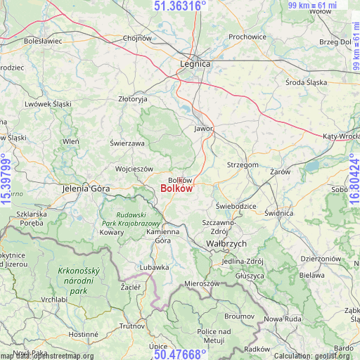
Bolków GPS coordinates[2]
50° 55' 19.308" North, 16° 6' 3.996" East
| Map corner | latitude | longitude |
|---|---|---|
| Upper-left | 51.36316°, | 15.39799° |
| Center: | 50.92203°, | 16.10111° |
| Lower-right: | 50.47668°, | 16.80424° |
| Map W x H: | 98.6×98.6 km | = 61.3×61.3mi |
| max Lat: | 54.83135° ⇑57.1% North |
| Bolków: | 50.92203° |
| min Lat: | ⇓42.9% South 49.21328° |
| min Long | Bolków | max Long |
| 14.20249° | 16.10111° | 24.03723° |
| W 8.1%⇐ | ⇒91.9% E |
Elevation
Elevation of Bolków is 339 m = 1112 ft, and this is 147.6 m = 484 ft above average elevation for this country.
| Max E: |
974 m = 3196 ft | 9.3% |
| Bolków | 339 m 1112 ft | |
| Avg. | 191.4 m = 628 ft | |
Min E: |
-3 m = -10 ft | 90.7% |
See also: Poland elevation on elevation.city.
Geographical zone
Bolków is located in North temperate zone (between Tropic of Cancer and the Arctic Circle). Distance of this North polar circle is 1739.2 km =1080.7 mi to North.| Distance of | km | miles | from Bolków |
|---|---|---|---|
| North Pole | 4345.1 | 2699.9 | to North |
| Arctic Circle | 1739.2 | 1080.7 | to North |
| Tropic Cancer | 3056.1 | 1899 | to South |
| Equator | 5662 | 3518.2 | to South |


Nearby cities:
15 places around Bolków: (largest is in red/bold)
• Czarny Bór
16.9 km =10.5 mi,  173°
173°
• Dobromierz
9.9 km =6.2 mi,  96°
96°
• Janowice Wielkie
13.5 km =8.4 mi,  247°
247°
• Jawor
15.8 km =9.8 mi,  24°
24°
• Kamienna Góra
16.2 km =10.1 mi,  197°
197°
• Marciszów
10.3 km =6.4 mi,  213°
213°
• Męcinka
16.9 km =10.5 mi,  358°
358°
• Paszowice
10.5 km =6.5 mi, 20°
• Stare Bogaczowice
10.5 km =6.5 mi,  142°
142°
• Strzegom
18 km =11.2 mi,  75°
75°
• Szczawno-Zdrój
17.1 km =10.6 mi, 140°
• Wierzchosławice
3.5 km =2.2 mi,  190°
190°
• Wojcieszów
13 km =8.1 mi,  284°
284°
• Świebodzice
16.8 km =10.4 mi,  114°
114°
• Świerzawa
17.7 km =11 mi,  305°
305°
Sources, notices
• [Note1] Compared only with cities in Poland existing in our database
• [Src1] Map data: © OpenStreetMap contributors (CC-BY-SA)
• [Src2] Other city data from geonames.org with taken over terms of usage.
• [Src3] Geographical zone / Annual Mean Temperature by Robert A. Rohde @ Wikipedia
