Dobrocin geodata
Dobrocin (Lower Silesia) is a populated place; located in Poland in Europe/Warsaw (GMT+2) time zone. With population of 800 people, there are 2851 cities with bigger population in this country. Compared to other cities in Poland, 61.9% of cities are located further ↑North; 88% of cities are located further →East and 83.9% of cities have lower elevation than Dobrocin. Note1
Administrative division(s):
- Level 1: Lower Silesia
- Level 2: Powiat dzierżoniowski
- Level 3: Dzierżoniów


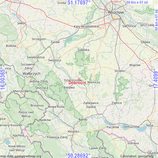
Dobrocin GPS coordinates[2]
50° 44' 2.616" North, 16° 42' 24.372" East
| Map corner | latitude | longitude |
|---|---|---|
| Upper-left | 51.17697°, | 16.00365° |
| Center: | 50.73406°, | 16.70677° |
| Lower-right: | 50.28692°, | 17.4099° |
| Map W x H: | 99×99 km | = 61.5×61.5mi |
| max Lat: | 54.83135° ⇑61.9% North |
| Dobrocin: | 50.73406° |
| min Lat: | ⇓38.1% South 49.21328° |
| min Long | Dobrocin | max Long |
| 14.20249° | 16.70677° | 24.03723° |
| W 12%⇐ | ⇒88% E |
Elevation
Elevation of Dobrocin is 285 m = 935 ft, and this is 93.6 m = 307 ft above average elevation for this country.
| Max E: |
974 m = 3196 ft | 16.1% |
| Dobrocin | 285 m 935 ft | |
| Avg. | 191.4 m = 628 ft | |
Min E: |
-3 m = -10 ft | 83.9% |
See also: Poland elevation on elevation.city.
Geographical zone
Dobrocin is located in North temperate zone (between Tropic of Cancer and the Arctic Circle). Distance of this North polar circle is 1760.1 km =1093.7 mi to North.| Distance of | km | miles | from Dobrocin |
|---|---|---|---|
| North Pole | 4366 | 2712.9 | to North |
| Arctic Circle | 1760.1 | 1093.7 | to North |
| Tropic Cancer | 3035.2 | 1886 | to South |
| Equator | 5641.1 | 3505.2 | to South |


Nearby cities:
15 places around Dobrocin: (largest is in red/bold)
• Bielawa
7.6 km =4.7 mi,  230°
230°
• Bobolice
16.4 km =10.2 mi,  139°
139°
• Budzów
15.6 km =9.7 mi,  179°
179°
• Ciepłowody
15.7 km =9.8 mi,  114°
114°
• Dzierżoniów
4 km =2.5 mi,  260°
260°
• Jodłownik
11.9 km =7.4 mi,  213°
213°
• Kondratowice
16.6 km =10.3 mi,  74°
74°
• Niemcza
9.2 km =5.7 mi,  99°
99°
• Ostroszowice
10.9 km =6.8 mi, 205°
• Pieszyce
9.1 km =5.7 mi,  254°
254°
• Piława Górna
6.2 km =3.9 mi,  155°
155°
• Stoszowice
15.1 km =9.4 mi,  171°
171°
• Uciechów
2.9 km =1.8 mi,  322°
322°
• Wilków Wielki
10.2 km =6.3 mi,  77°
77°
• Łagiewniki
11.6 km =7.2 mi,  56°
56°
Sources, notices
• [Note1] Compared only with cities in Poland existing in our database
• [Src1] Map data: © OpenStreetMap contributors (CC-BY-SA)
• [Src2] Other city data from geonames.org with taken over terms of usage.
• [Src3] Geographical zone / Annual Mean Temperature by Robert A. Rohde @ Wikipedia
