Strzelin geodata
Strzelin (Lower Silesia) is a populated place; located in Poland in Europe/Warsaw (GMT+2) time zone. With population of 12,394 people, there are 382 cities with bigger population in this country. Compared to other cities in Poland, 60.6% of cities are located further ↑North; 83.7% of cities are located further →East and 52.9% of cities have higher elevation than Strzelin. Note1


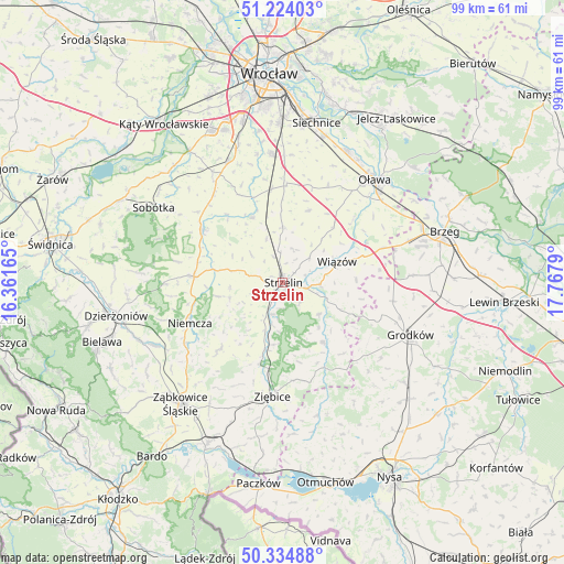
Strzelin GPS coordinates[2]
50° 46' 53.652" North, 17° 3' 53.172" East
| Map corner | latitude | longitude |
|---|---|---|
| Upper-left | 51.22403°, | 16.36165° |
| Center: | 50.78157°, | 17.06477° |
| Lower-right: | 50.33488°, | 17.7679° |
| Map W x H: | 98.9×98.9 km | = 61.5×61.5mi |
| max Lat: | 54.83135° ⇑60.6% North |
| Strzelin: | 50.78157° |
| min Lat: | ⇓39.4% South 49.21328° |
| min Long | Strzelin | max Long |
| 14.20249° | 17.06477° | 24.03723° |
| W 16.3%⇐ | ⇒83.7% E |
Elevation
Elevation of Strzelin is 164 m = 538 ft, and this is 27.4 m = 90 ft below average elevation for this country.
| Max E: |
974 m = 3196 ft | 52.9% |
| Avg. | 191.4 m = 628 ft | |
| Strzelin | 164 m = 538 ft | |
Min E: |
-3 m = -10 ft | 47.1% |
See also: Poland elevation on elevation.city.
Geographical zone
Strzelin is located in North temperate zone (between Tropic of Cancer and the Arctic Circle). Distance of this North polar circle is 1754.8 km =1090.4 mi to North.| Distance of | km | miles | from Strzelin |
|---|---|---|---|
| North Pole | 4360.7 | 2709.6 | to North |
| Arctic Circle | 1754.8 | 1090.4 | to North |
| Tropic Cancer | 3040.5 | 1889.3 | to South |
| Equator | 5646.4 | 3508.5 | to South |


Nearby cities:
15 places around Strzelin: (largest is in red/bold)
• Borów
12.4 km =7.7 mi,  335°
335°
• Ciepłowody
16.2 km =10.1 mi,  222°
222°
• Domaniów
13.3 km =8.3 mi,  20°
20°
• Henryków
14.8 km =9.2 mi,  195°
195°
• Jordanów Śląski
16.6 km =10.3 mi,  303°
303°
• Kondratowice
9.2 km =5.7 mi,  264°
264°
• Niemcza
17.5 km =10.9 mi,  247°
247°
• Osiek
19.8 km =12.3 mi,  53°
53°
• Przeworno
12.8 km =8 mi,  146°
146°
• Wierzbno
19 km =11.8 mi,  25°
25°
• Wilków Wielki
15.5 km =9.6 mi, 258°
• Wiązów
10.3 km =6.4 mi,  69°
69°
• Węgry
16.4 km =10.2 mi,  353°
353°
• Ziębice
20.1 km =12.5 mi,  184°
184°
• Łagiewniki
15.5 km =9.6 mi,  273°
273°
Sources, notices
• [Note1] Compared only with cities in Poland existing in our database
• [Src1] Map data: © OpenStreetMap contributors (CC-BY-SA)
• [Src2] Other city data from geonames.org with taken over terms of usage.
• [Src3] Geographical zone / Annual Mean Temperature by Robert A. Rohde @ Wikipedia
