Wilków Wielki geodata
Wilków Wielki (Lower Silesia) is a populated place; located in Poland in Europe/Warsaw (GMT+2) time zone. With population of 504 people, there are 3531 cities with bigger population in this country. Compared to other cities in Poland, 61.3% of cities are located further ↑North; 86.8% of cities are located further →East and 52.6% of cities have lower elevation than Wilków Wielki. Note1


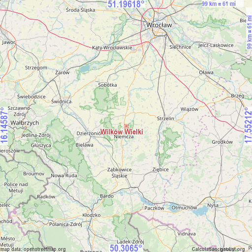
Wilków Wielki GPS coordinates[2]
50° 45' 12.42" North, 16° 50' 56.364" East
| Map corner | latitude | longitude |
|---|---|---|
| Upper-left | 51.19618°, | 16.14587° |
| Center: | 50.75345°, | 16.84899° |
| Lower-right: | 50.3065°, | 17.55212° |
| Map W x H: | 98.9×98.9 km | = 61.5×61.5mi |
| max Lat: | 54.83135° ⇑61.3% North |
| Wilków Wielki: | 50.75345° |
| min Lat: | ⇓38.7% South 49.21328° |
| min Long | Wilków Wielki | max Long |
| 14.20249° | 16.84899° | 24.03723° |
| W 13.2%⇐ | ⇒86.8% E |
Elevation
Elevation of Wilków Wielki is 179 m = 587 ft, and this is 12.4 m = 41 ft below average elevation for this country.
| Max E: |
974 m = 3196 ft | 47.4% |
| Avg. | 191.4 m = 628 ft | |
| Wilków Wielki | 179 m = 587 ft | |
Min E: |
-3 m = -10 ft | 52.6% |
See also: Poland elevation on elevation.city.
Geographical zone
Wilków Wielki is located in North temperate zone (between Tropic of Cancer and the Arctic Circle). Distance of this North polar circle is 1757.9 km =1092.3 mi to North.| Distance of | km | miles | from Wilków Wielki |
|---|---|---|---|
| North Pole | 4363.8 | 2711.5 | to North |
| Arctic Circle | 1757.9 | 1092.3 | to North |
| Tropic Cancer | 3037.3 | 1887.3 | to South |
| Equator | 5643.3 | 3506.6 | to South |


Nearby cities:
15 places around Wilków Wielki: (largest is in red/bold)
• Bielawa
17.4 km =10.8 mi,  246°
246°
• Bobolice
14.6 km =9.1 mi,  177°
177°
• Borów
17.6 km =10.9 mi,  34°
34°
• Ciepłowody
9.7 km =6 mi,  154°
154°
• Dobrocin
10.2 km =6.3 mi,  257°
257°
• Dzierżoniów
14.2 km =8.8 mi, 258°
• Henryków
15.9 km =9.9 mi,  134°
134°
• Jordanów Śląski
12.4 km =7.7 mi,  6°
6°
• Kondratowice
6.4 km =4 mi,  69°
69°
• Niemcza
3.8 km =2.4 mi,  194°
194°
• Piława Górna
10.7 km =6.6 mi,  223°
223°
• Sobótka
17.9 km =11.1 mi,  335°
335°
• Strzelin
15.5 km =9.6 mi,  78°
78°
• Uciechów
11.8 km =7.3 mi,  270°
270°
• Łagiewniki
4.2 km =2.6 mi,  355°
355°
Sources, notices
• [Note1] Compared only with cities in Poland existing in our database
• [Src1] Map data: © OpenStreetMap contributors (CC-BY-SA)
• [Src2] Other city data from geonames.org with taken over terms of usage.
• [Src3] Geographical zone / Annual Mean Temperature by Robert A. Rohde @ Wikipedia
