Gierzwałd geodata
Gierzwałd (Warmia-Masuria) is a seat of a third-order administrative division; located in Poland in Europe/Warsaw (GMT+2) time zone. With population of 638 people, there are 3194 cities with bigger population in this country. Compared to other cities in Poland, 90.1% of cities are located further ↓South; 59.7% of cities are located further ←West and 57.7% of cities have lower elevation than Gierzwałd. Note1


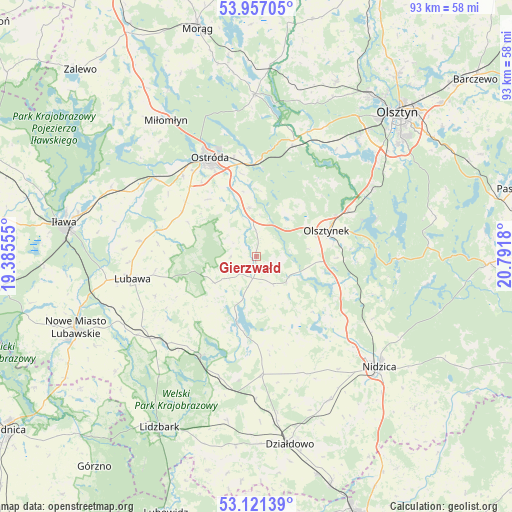
Gierzwałd GPS coordinates[2]
53° 32' 28.608" North, 20° 5' 19.212" East
| Map corner | latitude | longitude |
|---|---|---|
| Upper-left | 53.95705°, | 19.38555° |
| Center: | 53.54128°, | 20.08867° |
| Lower-right: | 53.12139°, | 20.7918° |
| Map W x H: | 92.9×92.9 km | = 57.7×57.7mi |
| max Lat: | 54.83135° ⇑9.9% North |
| Gierzwałd: | 53.54128° |
| min Lat: | ⇓90.1% South 49.21328° |
| min Long | Gierzwałd | max Long |
| 14.20249° | 20.08867° | 24.03723° |
| W 59.7%⇐ | ⇒40.3% E |
Elevation
Elevation of Gierzwałd is 193 m = 633 ft, and this is 1.6 m = 5 ft above average elevation for this country.
| Max E: |
974 m = 3196 ft | 42.3% |
| Gierzwałd | 193 m 633 ft | |
| Avg. | 191.4 m = 628 ft | |
Min E: |
-3 m = -10 ft | 57.7% |
See also: Poland elevation on elevation.city.
Geographical zone
Gierzwałd is located in North temperate zone (between Tropic of Cancer and the Arctic Circle). Distance of this North polar circle is 1447.9 km =899.7 mi to North.| Distance of | km | miles | from Gierzwałd |
|---|---|---|---|
| North Pole | 4053.8 | 2518.9 | to North |
| Arctic Circle | 1447.9 | 899.7 | to North |
| Tropic Cancer | 3347.3 | 2079.9 | to South |
| Equator | 5953.2 | 3699.1 | to South |


Nearby cities:
15 places around Gierzwałd: (largest is in red/bold)
• Dąbrówno
12.4 km =7.7 mi,  196°
196°
• Gietrzwałd
24.8 km =15.4 mi,  23°
23°
• Grabowo
17.9 km =11.1 mi,  277°
277°
• Grodziczno
25.9 km =16.1 mi,  236°
236°
• Grunwald
6.4 km =4 mi,  176°
176°
• Kozłowo
29.3 km =18.2 mi,  152°
152°
• Lubawa
22.8 km =14.2 mi,  259°
259°
• Mielno
7.6 km =4.7 mi,  113°
113°
• Miłomłyn
29.8 km =18.5 mi,  326°
326°
• Nidzica
30.1 km =18.7 mi,  131°
131°
• Olsztynek
13.8 km =8.6 mi,  69°
69°
• Ostróda
19.1 km =11.9 mi, 334°
• Rybno
20.4 km =12.7 mi,  210°
210°
• Stawiguda
24.3 km =15.1 mi,  57°
57°
• Łukta
29.3 km =18.2 mi,  359°
359°
Sources, notices
• [Note1] Compared only with cities in Poland existing in our database
• [Src1] Map data: © OpenStreetMap contributors (CC-BY-SA)
• [Src2] Other city data from geonames.org with taken over terms of usage.
• [Src3] Geographical zone / Annual Mean Temperature by Robert A. Rohde @ Wikipedia
