Rozkochów geodata
Rozkochów (Opole Voivodeship) is a populated place; located in Poland in Europe/Warsaw (GMT+2) time zone. With population of 640 people, there are 3187 cities with bigger population in this country. Compared to other cities in Poland, 70.3% of cities are located further ↑North; 75.8% of cities are located further →East and 57.3% of cities have lower elevation than Rozkochów. Note1


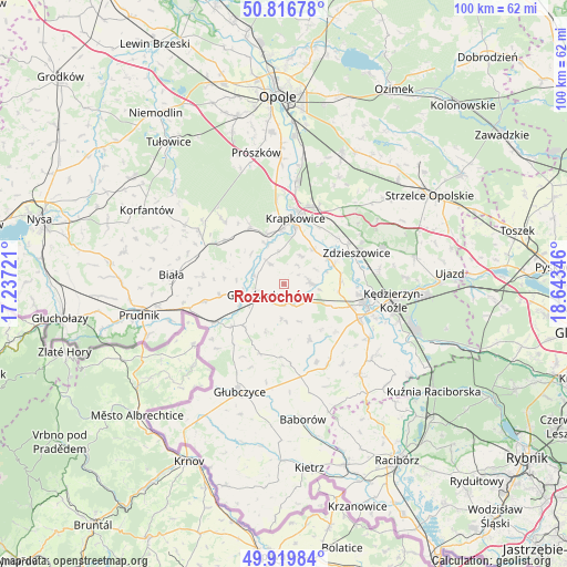
Rozkochów GPS coordinates[2]
50° 22' 13.548" North, 17° 56' 25.188" East
| Map corner | latitude | longitude |
|---|---|---|
| Upper-left | 50.81678°, | 17.23721° |
| Center: | 50.37043°, | 17.94033° |
| Lower-right: | 49.91984°, | 18.64346° |
| Map W x H: | 99.7×99.7 km | = 62×62mi |
| max Lat: | 54.83135° ⇑70.3% North |
| Rozkochów: | 50.37043° |
| min Lat: | ⇓29.7% South 49.21328° |
| min Long | Rozkochów | max Long |
| 14.20249° | 17.94033° | 24.03723° |
| W 24.2%⇐ | ⇒75.8% E |
Elevation
Elevation of Rozkochów is 191 m = 627 ft, and this is 0.40000000000001 m = 1 ft below average elevation for this country.
| Max E: |
974 m = 3196 ft | 42.7% |
| Avg. | 191.4 m = 628 ft | |
| Rozkochów | 191 m = 627 ft | |
Min E: |
-3 m = -10 ft | 57.3% |
See also: Poland elevation on elevation.city.
Geographical zone
Rozkochów is located in North temperate zone (between Tropic of Cancer and the Arctic Circle). Distance of this North polar circle is 1800.5 km =1118.8 mi to North.| Distance of | km | miles | from Rozkochów |
|---|---|---|---|
| North Pole | 4406.4 | 2738 | to North |
| Arctic Circle | 1800.5 | 1118.8 | to North |
| Tropic Cancer | 2994.7 | 1860.8 | to South |
| Equator | 5600.7 | 3480.1 | to South |


Nearby cities:
15 places around Rozkochów: (largest is in red/bold)
• Dobieszowice
6.1 km =3.8 mi,  98°
98°
• Dobra
9.3 km =5.8 mi,  345°
345°
• Głogówek
5.7 km =3.5 mi,  250°
250°
• Komorno
9.6 km =6 mi, 98°
• Krapkowice
11.8 km =7.3 mi,  8°
8°
• Kujawy
12.5 km =7.8 mi,  310°
310°
• Kórnica
4.5 km =2.8 mi,  326°
326°
• Poborszów
10.2 km =6.3 mi,  87°
87°
• Pokrzywnica
9.6 km =6 mi,  115°
115°
• Racławice Śląskie
13.4 km =8.3 mi,  240°
240°
• Rozwadza
13.4 km =8.3 mi,  57°
57°
• Strzeleczki
11.8 km =7.3 mi, 329°
• Twardawa
4.7 km =2.9 mi,  129°
129°
• Walce
4.5 km =2.8 mi, 86°
• Większyce
12.1 km =7.5 mi,  108°
108°
Sources, notices
• [Note1] Compared only with cities in Poland existing in our database
• [Src1] Map data: © OpenStreetMap contributors (CC-BY-SA)
• [Src2] Other city data from geonames.org with taken over terms of usage.
• [Src3] Geographical zone / Annual Mean Temperature by Robert A. Rohde @ Wikipedia
