Branice geodata
Branice (Opole Voivodeship) is a seat of a third-order administrative division; located in Poland in Europe/Warsaw (GMT+2) time zone. With population of 2,300 people, there are 1321 cities with bigger population in this country. Compared to other cities in Poland, 80.1% of cities are located further ↑North; 77.3% of cities are located further →East and 87.5% of cities have lower elevation than Branice. Note1


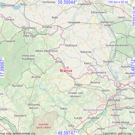
Branice GPS coordinates[2]
50° 3' 3.888" North, 17° 47' 38.364" East
| Map corner | latitude | longitude |
|---|---|---|
| Upper-left | 50.50044°, | 17.09087° |
| Center: | 50.05108°, | 17.79399° |
| Lower-right: | 49.59747°, | 18.49712° |
| Map W x H: | 100.4×100.4 km | = 62.4×62.4mi |
| max Lat: | 54.83135° ⇑80.1% North |
| Branice: | 50.05108° |
| min Lat: | ⇓19.9% South 49.21328° |
| min Long | Branice | max Long |
| 14.20249° | 17.79399° | 24.03723° |
| W 22.7%⇐ | ⇒77.3% E |
Elevation
Elevation of Branice is 305 m = 1001 ft, and this is 113.6 m = 373 ft above average elevation for this country.
| Max E: |
974 m = 3196 ft | 12.5% |
| Branice | 305 m 1001 ft | |
| Avg. | 191.4 m = 628 ft | |
Min E: |
-3 m = -10 ft | 87.5% |
See also: Poland elevation on elevation.city.
Geographical zone
Branice is located in North temperate zone (between Tropic of Cancer and the Arctic Circle). Distance of this North polar circle is 1836 km =1140.8 mi to North.| Distance of | km | miles | from Branice |
|---|---|---|---|
| North Pole | 4441.9 | 2760.1 | to North |
| Arctic Circle | 1836 | 1140.8 | to North |
| Tropic Cancer | 2959.2 | 1838.8 | to South |
| Equator | 5565.2 | 3458.1 | to South |


Nearby cities:
15 places around Branice: (largest is in red/bold)
• Baborów
18.1 km =11.2 mi,  49°
49°
• Bojanów
26.6 km =16.5 mi,  95°
95°
• Borucin
26.4 km =16.4 mi, 100°
• Głubczyce
16.8 km =10.4 mi,  8°
8°
• Kietrz
15.4 km =9.6 mi,  77°
77°
• Krzanowice
23.7 km =14.7 mi, 98°
• Maków
21.6 km =13.4 mi,  72°
72°
• Ostrożnica
29.7 km =18.5 mi,  43°
43°
• Pawłowiczki
28.3 km =17.6 mi, 39°
• Pawłów
24.8 km =15.4 mi, 74°
• Pietrowice Wielkie
21.6 km =13.4 mi, 80°
• Pilszcz
10.6 km =6.6 mi,  123°
123°
• Racławice Śląskie
29 km =18 mi,  357°
357°
• Rudnik
29.2 km =18.1 mi, 73°
• Wysoka
3.5 km =2.2 mi,  149°
149°
Sources, notices
• [Note1] Compared only with cities in Poland existing in our database
• [Src1] Map data: © OpenStreetMap contributors (CC-BY-SA)
• [Src2] Other city data from geonames.org with taken over terms of usage.
• [Src3] Geographical zone / Annual Mean Temperature by Robert A. Rohde @ Wikipedia
