Twardawa geodata
Twardawa (Opole Voivodeship) is a populated place; located in Poland in Europe/Warsaw (GMT+2) time zone. With population of 1,029 people, there are 2421 cities with bigger population in this country. Compared to other cities in Poland, 71% of cities are located further ↑North; 75.4% of cities are located further →East and 57.7% of cities have lower elevation than Twardawa. Note1


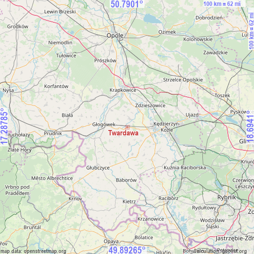
Twardawa GPS coordinates[2]
50° 20' 36.564" North, 17° 59' 27.492" East
| Map corner | latitude | longitude |
|---|---|---|
| Upper-left | 50.7901°, | 17.28785° |
| Center: | 50.34349°, | 17.99097° |
| Lower-right: | 49.89265°, | 18.6941° |
| Map W x H: | 99.8×99.8 km | = 62×62mi |
| max Lat: | 54.83135° ⇑71% North |
| Twardawa: | 50.34349° |
| min Lat: | ⇓29% South 49.21328° |
| min Long | Twardawa | max Long |
| 14.20249° | 17.99097° | 24.03723° |
| W 24.6%⇐ | ⇒75.4% E |
Elevation
Elevation of Twardawa is 193 m = 633 ft, and this is 1.6 m = 5 ft above average elevation for this country.
| Max E: |
974 m = 3196 ft | 42.3% |
| Twardawa | 193 m 633 ft | |
| Avg. | 191.4 m = 628 ft | |
Min E: |
-3 m = -10 ft | 57.7% |
See also: Poland elevation on elevation.city.
Geographical zone
Twardawa is located in North temperate zone (between Tropic of Cancer and the Arctic Circle). Distance of this North polar circle is 1803.5 km =1120.6 mi to North.| Distance of | km | miles | from Twardawa |
|---|---|---|---|
| North Pole | 4409.4 | 2739.9 | to North |
| Arctic Circle | 1803.5 | 1120.6 | to North |
| Tropic Cancer | 2991.8 | 1859 | to South |
| Equator | 5597.7 | 3478.2 | to South |


Nearby cities:
15 places around Twardawa: (largest is in red/bold)
• Dobieszowice
3.3 km =2.1 mi,  49°
49°
• Głogówek
9.1 km =5.7 mi,  277°
277°
• Januszkowice
11.7 km =7.3 mi,  62°
62°
• Komorno
6.1 km =3.8 mi,  75°
75°
• Koźle
10.8 km =6.7 mi,  94°
94°
• Kórnica
9.1 km =5.7 mi,  318°
318°
• Ostrożnica
12.9 km =8 mi,  149°
149°
• Pawłowiczki
11.5 km =7.1 mi,  159°
159°
• Poborszów
7.4 km =4.6 mi, 61°
• Pokrzywnica
5.2 km =3.2 mi,  103°
103°
• Reńska Wieś
10.1 km =6.3 mi,  107°
107°
• Rozkochów
4.7 km =2.9 mi,  309°
309°
• Rozwadza
12.8 km =8 mi,  37°
37°
• Walce
3.4 km =2.1 mi,  15°
15°
• Większyce
7.9 km =4.9 mi, 95°
Sources, notices
• [Note1] Compared only with cities in Poland existing in our database
• [Src1] Map data: © OpenStreetMap contributors (CC-BY-SA)
• [Src2] Other city data from geonames.org with taken over terms of usage.
• [Src3] Geographical zone / Annual Mean Temperature by Robert A. Rohde @ Wikipedia
