Baborów geodata
Baborów (Opole Voivodeship) is a seat of a third-order administrative division; located in Poland in Europe/Warsaw (GMT+2) time zone. With population of 3,114 people, there are 1012 cities with bigger population in this country. Compared to other cities in Poland, 75.7% of cities are located further ↑North; 75.4% of cities are located further →East and 70.6% of cities have lower elevation than Baborów. Note1


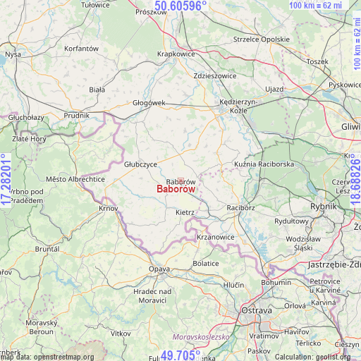
Baborów GPS coordinates[2]
50° 9' 27.36" North, 17° 59' 6.468" East
| Map corner | latitude | longitude |
|---|---|---|
| Upper-left | 50.60596°, | 17.28201° |
| Center: | 50.1576°, | 17.98513° |
| Lower-right: | 49.705°, | 18.68826° |
| Map W x H: | 100.2×100.2 km | = 62.3×62.3mi |
| max Lat: | 54.83135° ⇑75.7% North |
| Baborów: | 50.1576° |
| min Lat: | ⇓24.3% South 49.21328° |
| min Long | Baborów | max Long |
| 14.20249° | 17.98513° | 24.03723° |
| W 24.6%⇐ | ⇒75.4% E |
Elevation
Elevation of Baborów is 231 m = 758 ft, and this is 39.6 m = 130 ft above average elevation for this country.
| Max E: |
974 m = 3196 ft | 29.4% |
| Baborów | 231 m 758 ft | |
| Avg. | 191.4 m = 628 ft | |
Min E: |
-3 m = -10 ft | 70.6% |
See also: Poland elevation on elevation.city.
Geographical zone
Baborów is located in North temperate zone (between Tropic of Cancer and the Arctic Circle). Distance of this North polar circle is 1824.2 km =1133.5 mi to North.| Distance of | km | miles | from Baborów |
|---|---|---|---|
| North Pole | 4430.1 | 2752.7 | to North |
| Arctic Circle | 1824.2 | 1133.5 | to North |
| Tropic Cancer | 2971.1 | 1846.2 | to South |
| Equator | 5577 | 3465.4 | to South |


Nearby cities:
15 places around Baborów: (largest is in red/bold)
• Branice
18.1 km =11.2 mi,  229°
229°
• Brzeźnica
16.9 km =10.5 mi,  93°
93°
• Długomiłowice
18.2 km =11.3 mi,  39°
39°
• Głubczyce
12.1 km =7.5 mi,  293°
293°
• Kietrz
8.7 km =5.4 mi,  170°
170°
• Krzanowice
18.3 km =11.4 mi,  147°
147°
• Maków
8.8 km =5.5 mi,  127°
127°
• Ostrożnica
11.8 km =7.3 mi, 36°
• Pawłowiczki
10.9 km =6.8 mi,  24°
24°
• Pawłów
11.5 km =7.1 mi,  116°
116°
• Pietrowice Wielkie
11.1 km =6.9 mi,  136°
136°
• Pilszcz
18.3 km =11.4 mi,  195°
195°
• Polska Cerekiew
12.8 km =8 mi,  52°
52°
• Racibórz
18.2 km =11.3 mi,  113°
113°
• Rudnik
14.7 km =9.1 mi,  103°
103°
Sources, notices
• [Note1] Compared only with cities in Poland existing in our database
• [Src1] Map data: © OpenStreetMap contributors (CC-BY-SA)
• [Src2] Other city data from geonames.org with taken over terms of usage.
• [Src3] Geographical zone / Annual Mean Temperature by Robert A. Rohde @ Wikipedia
