Domaniewice geodata
Domaniewice (Łódź Voivodeship) is a seat of a third-order administrative division; located in Poland in Europe/Warsaw (GMT+2) time zone. With population of 906 people, there are 2664 cities with bigger population in this country. Compared to other cities in Poland, 65.7% of cities are located further ↓South; 55% of cities are located further ←West and 67.4% of cities have higher elevation than Domaniewice. Note1


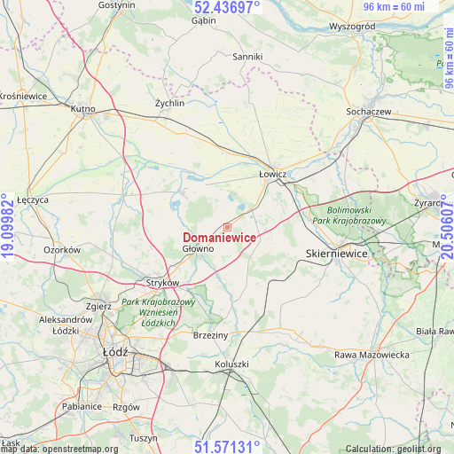
Domaniewice GPS coordinates[2]
52° 0' 22.428" North, 19° 48' 10.584" East
| Map corner | latitude | longitude |
|---|---|---|
| Upper-left | 52.43697°, | 19.09982° |
| Center: | 52.00623°, | 19.80294° |
| Lower-right: | 51.57131°, | 20.50607° |
| Map W x H: | 96.3×96.3 km | = 59.8×59.8mi |
| max Lat: | 54.83135° ⇑34.3% North |
| Domaniewice: | 52.00623° |
| min Lat: | ⇓65.7% South 49.21328° |
| min Long | Domaniewice | max Long |
| 14.20249° | 19.80294° | 24.03723° |
| W 55%⇐ | ⇒45% E |
Elevation
Elevation of Domaniewice is 127 m = 417 ft, and this is 64.4 m = 211 ft below average elevation for this country.
| Max E: |
974 m = 3196 ft | 67.4% |
| Avg. | 191.4 m = 628 ft | |
| Domaniewice | 127 m = 417 ft | |
Min E: |
-3 m = -10 ft | 32.6% |
See also: Poland elevation on elevation.city.
Geographical zone
Domaniewice is located in North temperate zone (between Tropic of Cancer and the Arctic Circle). Distance of this North polar circle is 1618.6 km =1005.8 mi to North.| Distance of | km | miles | from Domaniewice |
|---|---|---|---|
| North Pole | 4224.5 | 2625 | to North |
| Arctic Circle | 1618.6 | 1005.8 | to North |
| Tropic Cancer | 3176.6 | 1973.8 | to South |
| Equator | 5782.6 | 3593.1 | to South |


Nearby cities:
15 places around Domaniewice: (largest is in red/bold)
• Bielawy
12.7 km =7.9 mi,  307°
307°
• Bobrowniki
16.2 km =10.1 mi,  66°
66°
• Dmosin
9.6 km =6 mi,  198°
198°
• Godzianów
20.1 km =12.5 mi,  127°
127°
• Głowno
7.6 km =4.7 mi,  232°
232°
• Lipce Reymontowskie
15.3 km =9.5 mi,  141°
141°
• Maków
18.3 km =11.4 mi,  111°
111°
• Nieborów
19.9 km =12.4 mi, 66°
• Nowe Zduny
15.3 km =9.5 mi,  1°
1°
• Rogoźno
3.9 km =2.4 mi,  9°
9°
• Stryków
17.8 km =11.1 mi, 229°
• Słupia
20.3 km =12.6 mi,  145°
145°
• Zduny
16.7 km =10.4 mi, 3°
• Łowicz
14.9 km =9.3 mi,  40°
40°
• Łyszkowice
7.5 km =4.7 mi, 107°
Sources, notices
• [Note1] Compared only with cities in Poland existing in our database
• [Src1] Map data: © OpenStreetMap contributors (CC-BY-SA)
• [Src2] Other city data from geonames.org with taken over terms of usage.
• [Src3] Geographical zone / Annual Mean Temperature by Robert A. Rohde @ Wikipedia
