Stryków geodata
Stryków (Łódź Voivodeship) is a seat of a third-order administrative division; located in Poland in Europe/Warsaw (GMT+2) time zone. With population of 3,297 people, there are 967 cities with bigger population in this country. Compared to other cities in Poland, 63.7% of cities are located further ↓South; 50.8% of cities are located further ←West and 54.5% of cities have higher elevation than Stryków. Note1


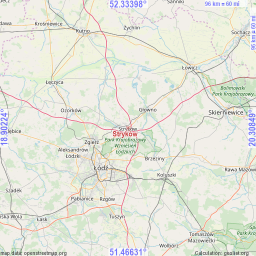
Stryków GPS coordinates[2]
51° 54' 8.064" North, 19° 36' 19.296" East
| Map corner | latitude | longitude |
|---|---|---|
| Upper-left | 52.33398°, | 18.90224° |
| Center: | 51.90224°, | 19.60536° |
| Lower-right: | 51.46631°, | 20.30849° |
| Map W x H: | 96.5×96.5 km | = 60×60mi |
| max Lat: | 54.83135° ⇑36.3% North |
| Stryków: | 51.90224° |
| min Lat: | ⇓63.7% South 49.21328° |
| min Long | Stryków | max Long |
| 14.20249° | 19.60536° | 24.03723° |
| W 50.8%⇐ | ⇒49.2% E |
Elevation
Elevation of Stryków is 160 m = 525 ft, and this is 31.4 m = 103 ft below average elevation for this country.
| Max E: |
974 m = 3196 ft | 54.5% |
| Avg. | 191.4 m = 628 ft | |
| Stryków | 160 m = 525 ft | |
Min E: |
-3 m = -10 ft | 45.5% |
See also: Poland elevation on elevation.city.
Geographical zone
Stryków is located in North temperate zone (between Tropic of Cancer and the Arctic Circle). Distance of this North polar circle is 1630.2 km =1013 mi to North.| Distance of | km | miles | from Stryków |
|---|---|---|---|
| North Pole | 4236.1 | 2632.2 | to North |
| Arctic Circle | 1630.2 | 1013 | to North |
| Tropic Cancer | 3165.1 | 1966.7 | to South |
| Equator | 5771 | 3585.9 | to South |


Nearby cities:
15 places around Stryków: (largest is in red/bold)
• Andrespol
19.6 km =12.2 mi,  172°
172°
• Bielawy
19.6 km =12.2 mi,  10°
10°
• Brzeziny
15.1 km =9.4 mi,  138°
138°
• Dmosin
10.8 km =6.7 mi,  76°
76°
• Dobra
4.7 km =2.9 mi,  219°
219°
• Domaniewice
17.8 km =11.1 mi,  49°
49°
• Gałków Duży
20.2 km =12.6 mi,  156°
156°
• Gałków Mały
21 km =13 mi, 159°
• Głowno
10.3 km =6.4 mi, 47°
• Piątek
20.4 km =12.7 mi,  335°
335°
• Rogoźno
20.9 km =13 mi,  42°
42°
• Rogów
21.5 km =13.4 mi,  115°
115°
• Szczawin
8 km =5 mi,  268°
268°
• Zgierz
14.6 km =9.1 mi,  249°
249°
• Łódź
17.2 km =10.7 mi,  211°
211°
Sources, notices
• [Note1] Compared only with cities in Poland existing in our database
• [Src1] Map data: © OpenStreetMap contributors (CC-BY-SA)
• [Src2] Other city data from geonames.org with taken over terms of usage.
• [Src3] Geographical zone / Annual Mean Temperature by Robert A. Rohde @ Wikipedia
