Słupia geodata
Słupia (Łódź Voivodeship) is a seat of a third-order administrative division; located in Poland in Europe/Warsaw (GMT+2) time zone. With population of 812 people, there are 2834 cities with bigger population in this country. Compared to other cities in Poland, 62.8% of cities are located further ↓South; 57.9% of cities are located further ←West and 52.5% of cities have higher elevation than Słupia. Note1


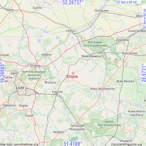
Słupia GPS coordinates[2]
51° 51' 18.648" North, 19° 58' 11.892" East
| Map corner | latitude | longitude |
|---|---|---|
| Upper-left | 52.28737°, | 19.26685° |
| Center: | 51.85518°, | 19.96997° |
| Lower-right: | 51.4188°, | 20.6731° |
| Map W x H: | 96.6×96.6 km | = 60×60mi |
| max Lat: | 54.83135° ⇑37.2% North |
| Słupia: | 51.85518° |
| min Lat: | ⇓62.8% South 49.21328° |
| min Long | Słupia | max Long |
| 14.20249° | 19.96997° | 24.03723° |
| W 57.9%⇐ | ⇒42.1% E |
Elevation
Elevation of Słupia is 165 m = 541 ft, and this is 26.4 m = 87 ft below average elevation for this country.
| Max E: |
974 m = 3196 ft | 52.5% |
| Avg. | 191.4 m = 628 ft | |
| Słupia | 165 m = 541 ft | |
Min E: |
-3 m = -10 ft | 47.5% |
See also: Poland elevation on elevation.city.
Geographical zone
Słupia is located in North temperate zone (between Tropic of Cancer and the Arctic Circle). Distance of this North polar circle is 1635.4 km =1016.2 mi to North.| Distance of | km | miles | from Słupia |
|---|---|---|---|
| North Pole | 4241.3 | 2635.4 | to North |
| Arctic Circle | 1635.4 | 1016.2 | to North |
| Tropic Cancer | 3159.8 | 1963.4 | to South |
| Equator | 5765.8 | 3582.7 | to South |


Nearby cities:
15 places around Słupia: (largest is in red/bold)
• Brzeziny
16.2 km =10.1 mi,  247°
247°
• Dmosin
16.4 km =10.2 mi,  298°
298°
• Godzianów
6.5 km =4 mi,  44°
44°
• Głuchów
11.2 km =7 mi,  138°
138°
• Jeżów
4.6 km =2.9 mi,  181°
181°
• Kawęczyn Nowy
19.3 km =12 mi,  79°
79°
• Koluszki
16.6 km =10.3 mi,  218°
218°
• Lipce Reymontowskie
5.2 km =3.2 mi,  338°
338°
• Maków
11.7 km =7.3 mi,  28°
28°
• Miedniewice
19.2 km =11.9 mi,  54°
54°
• Rogów
7.1 km =4.4 mi,  233°
233°
• Skierniewice
17 km =10.6 mi, 49°
• Złota
15.9 km =9.9 mi,  125°
125°
• Łyszkowice
15.1 km =9.4 mi, 343°
• Żelechlinek
16.5 km =10.3 mi,  164°
164°
Sources, notices
• [Note1] Compared only with cities in Poland existing in our database
• [Src1] Map data: © OpenStreetMap contributors (CC-BY-SA)
• [Src2] Other city data from geonames.org with taken over terms of usage.
• [Src3] Geographical zone / Annual Mean Temperature by Robert A. Rohde @ Wikipedia
