Godzianów geodata
Godzianów (Łódź Voivodeship) is a seat of a third-order administrative division; located in Poland in Europe/Warsaw (GMT+2) time zone. With population of 921 people, there are 2633 cities with bigger population in this country. Compared to other cities in Poland, 63.5% of cities are located further ↓South; 58.9% of cities are located further ←West and 56.7% of cities have higher elevation than Godzianów. Note1
Administrative division(s):
- Level 1: Łódź Voivodeship
- Level 2: Powiat skierniewicki
- Level 3: Godzianów


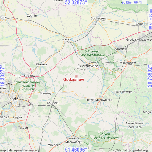
Godzianów GPS coordinates[2]
51° 53' 48.984" North, 20° 2' 9.204" East
| Map corner | latitude | longitude |
|---|---|---|
| Upper-left | 52.32873°, | 19.33277° |
| Center: | 51.89694°, | 20.03589° |
| Lower-right: | 51.46096°, | 20.73902° |
| Map W x H: | 96.5×96.5 km | = 60×60mi |
| max Lat: | 54.83135° ⇑36.5% North |
| Godzianów: | 51.89694° |
| min Lat: | ⇓63.5% South 49.21328° |
| min Long | Godzianów | max Long |
| 14.20249° | 20.03589° | 24.03723° |
| W 58.9%⇐ | ⇒41.1% E |
Elevation
Elevation of Godzianów is 154 m = 505 ft, and this is 37.4 m = 123 ft below average elevation for this country.
| Max E: |
974 m = 3196 ft | 56.7% |
| Avg. | 191.4 m = 628 ft | |
| Godzianów | 154 m = 505 ft | |
Min E: |
-3 m = -10 ft | 43.3% |
See also: Poland elevation on elevation.city.
Geographical zone
Godzianów is located in North temperate zone (between Tropic of Cancer and the Arctic Circle). Distance of this North polar circle is 1630.8 km =1013.3 mi to North.| Distance of | km | miles | from Godzianów |
|---|---|---|---|
| North Pole | 4236.7 | 2632.6 | to North |
| Arctic Circle | 1630.8 | 1013.3 | to North |
| Tropic Cancer | 3164.5 | 1966.3 | to South |
| Equator | 5770.4 | 3585.6 | to South |


Nearby cities:
15 places around Godzianów: (largest is in red/bold)
• Bobrowniki
18.7 km =11.6 mi,  356°
356°
• Dmosin
19.2 km =11.9 mi,  279°
279°
• Domaniewice
20.1 km =12.5 mi,  307°
307°
• Głuchów
13.4 km =8.3 mi,  167°
167°
• Jeżów
10.3 km =6.4 mi,  206°
206°
• Kawęczyn Nowy
14.5 km =9 mi,  94°
94°
• Lipce Reymontowskie
6.5 km =4 mi,  271°
271°
• Maków
5.7 km =3.5 mi,  11°
11°
• Miedniewice
12.8 km =8 mi,  59°
59°
• Nieborów
20.2 km =12.6 mi, 6°
• Rogów
13.5 km =8.4 mi,  229°
229°
• Skierniewice
10.6 km =6.6 mi,  52°
52°
• Słupia
6.5 km =4 mi,  224°
224°
• Złota
16.2 km =10.1 mi,  148°
148°
• Łyszkowice
13.3 km =8.3 mi,  318°
318°
Sources, notices
• [Note1] Compared only with cities in Poland existing in our database
• [Src1] Map data: © OpenStreetMap contributors (CC-BY-SA)
• [Src2] Other city data from geonames.org with taken over terms of usage.
• [Src3] Geographical zone / Annual Mean Temperature by Robert A. Rohde @ Wikipedia
