Zduny geodata
Zduny (Łódź Voivodeship) is a populated place; located in Poland in Europe/Warsaw (GMT+2) time zone. With population of 693 people, there are 3082 cities with bigger population in this country. Compared to other cities in Poland, 69.1% of cities are located further ↓South; 55.2% of cities are located further ←West and 82.7% of cities have higher elevation than Zduny. Note1


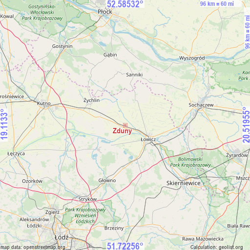
Zduny GPS coordinates[2]
52° 9' 21.708" North, 19° 48' 59.112" East
| Map corner | latitude | longitude |
|---|---|---|
| Upper-left | 52.58532°, | 19.1133° |
| Center: | 52.15603°, | 19.81642° |
| Lower-right: | 51.72256°, | 20.51955° |
| Map W x H: | 95.9×95.9 km | = 59.6×59.6mi |
| max Lat: | 54.83135° ⇑30.9% North |
| Zduny: | 52.15603° |
| min Lat: | ⇓69.1% South 49.21328° |
| min Long | Zduny | max Long |
| 14.20249° | 19.81642° | 24.03723° |
| W 55.2%⇐ | ⇒44.8% E |
Elevation
Elevation of Zduny is 94 m = 308 ft, and this is 97.4 m = 320 ft below average elevation for this country.
| Max E: |
974 m = 3196 ft | 82.7% |
| Avg. | 191.4 m = 628 ft | |
| Zduny | 94 m = 308 ft | |
Min E: |
-3 m = -10 ft | 17.3% |
See also: Poland elevation on elevation.city.
Geographical zone
Zduny is located in North temperate zone (between Tropic of Cancer and the Arctic Circle). Distance of this North polar circle is 1602 km =995.4 mi to North.| Distance of | km | miles | from Zduny |
|---|---|---|---|
| North Pole | 4207.9 | 2614.7 | to North |
| Arctic Circle | 1602 | 995.4 | to North |
| Tropic Cancer | 3193.3 | 1984.2 | to South |
| Equator | 5799.2 | 3603.5 | to South |


Nearby cities:
15 places around Zduny: (largest is in red/bold)
• Bedlno
17.4 km =10.8 mi,  289°
289°
• Bielawy
14.2 km =8.8 mi,  230°
230°
• Bobrowniki
17.2 km =10.7 mi,  126°
126°
• Chąśno
9.7 km =6 mi,  63°
63°
• Domaniewice
16.7 km =10.4 mi,  183°
183°
• Kiernozia
13.1 km =8.1 mi,  16°
16°
• Kocierzew Południowy
15.3 km =9.5 mi, 63°
• Nieborów
19.3 km =12 mi,  116°
116°
• Nowe Zduny
1.4 km =0.9 mi,  202°
202°
• Pacyna
17.9 km =11.1 mi,  336°
336°
• Rogoźno
12.8 km =8 mi, 181°
• Sanniki
19.7 km =12.2 mi,  10°
10°
• Łowicz
10.3 km =6.4 mi, 121°
• Łyszkowice
19.9 km =12.4 mi,  162°
162°
• Żychlin
16.2 km =10.1 mi,  307°
307°
Sources, notices
• [Note1] Compared only with cities in Poland existing in our database
• [Src1] Map data: © OpenStreetMap contributors (CC-BY-SA)
• [Src2] Other city data from geonames.org with taken over terms of usage.
• [Src3] Geographical zone / Annual Mean Temperature by Robert A. Rohde @ Wikipedia
