Nieborów geodata
Nieborów (Łódź Voivodeship) is a seat of a third-order administrative division; located in Poland in Europe/Warsaw (GMT+2) time zone. With population of 900 people, there are 2674 cities with bigger population in this country. Compared to other cities in Poland, 67.3% of cities are located further ↓South; 59.4% of cities are located further ←West and 84.6% of cities have higher elevation than Nieborów. Note1


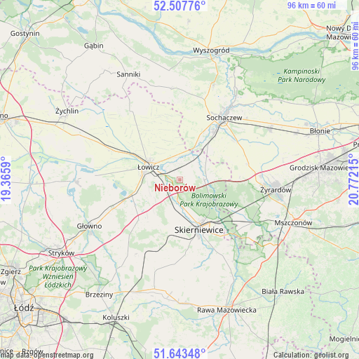
Nieborów GPS coordinates[2]
52° 4' 39.756" North, 20° 4' 8.472" East
| Map corner | latitude | longitude |
|---|---|---|
| Upper-left | 52.50776°, | 19.3659° |
| Center: | 52.07771°, | 20.06902° |
| Lower-right: | 51.64348°, | 20.77215° |
| Map W x H: | 96.1×96.1 km | = 59.7×59.7mi |
| max Lat: | 54.83135° ⇑32.7% North |
| Nieborów: | 52.07771° |
| min Lat: | ⇓67.3% South 49.21328° |
| min Long | Nieborów | max Long |
| 14.20249° | 20.06902° | 24.03723° |
| W 59.4%⇐ | ⇒40.6% E |
Elevation
Elevation of Nieborów is 90 m = 295 ft, and this is 101.4 m = 333 ft below average elevation for this country.
| Max E: |
974 m = 3196 ft | 84.6% |
| Avg. | 191.4 m = 628 ft | |
| Nieborów | 90 m = 295 ft | |
Min E: |
-3 m = -10 ft | 15.4% |
See also: Poland elevation on elevation.city.
Geographical zone
Nieborów is located in North temperate zone (between Tropic of Cancer and the Arctic Circle). Distance of this North polar circle is 1610.7 km =1000.8 mi to North.| Distance of | km | miles | from Nieborów |
|---|---|---|---|
| North Pole | 4216.6 | 2620.1 | to North |
| Arctic Circle | 1610.7 | 1000.8 | to North |
| Tropic Cancer | 3184.6 | 1978.8 | to South |
| Equator | 5790.5 | 3598 | to South |


Nearby cities:
15 places around Nieborów: (largest is in red/bold)
• Bobrowniki
3.7 km =2.3 mi,  246°
246°
• Bolimów
6.5 km =4 mi,  90°
90°
• Chąśno
15.7 km =9.8 mi,  326°
326°
• Franciszków
19 km =11.8 mi,  109°
109°
• Guzów
18.8 km =11.7 mi,  76°
76°
• Kocierzew Południowy
15.9 km =9.9 mi,  347°
347°
• Kozłów Biskupi
15.2 km =9.4 mi,  33°
33°
• Maków
14.6 km =9.1 mi,  184°
184°
• Miedniewice
15.9 km =9.9 mi, 87°
• Miedniewice
16.1 km =10 mi,  147°
147°
• Rogoźno
18 km =11.2 mi,  256°
256°
• Rybno
18.5 km =11.5 mi,  7°
7°
• Skierniewice
15 km =9.3 mi,  155°
155°
• Łowicz
9.1 km =5.7 mi,  291°
291°
• Łyszkowice
15.1 km =9.4 mi,  227°
227°
Sources, notices
• [Note1] Compared only with cities in Poland existing in our database
• [Src1] Map data: © OpenStreetMap contributors (CC-BY-SA)
• [Src2] Other city data from geonames.org with taken over terms of usage.
• [Src3] Geographical zone / Annual Mean Temperature by Robert A. Rohde @ Wikipedia
