Dmosin geodata
Dmosin (Łódź Voivodeship) is a seat of a third-order administrative division; located in Poland in Europe/Warsaw (GMT+2) time zone. With population of 1,500 people, there are 1837 cities with bigger population in this country. Compared to other cities in Poland, 64.3% of cities are located further ↓South; 53.9% of cities are located further ←West and 59.5% of cities have higher elevation than Dmosin. Note1


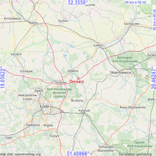
Dmosin GPS coordinates[2]
51° 55' 27.732" North, 19° 45' 33.624" East
| Map corner | latitude | longitude |
|---|---|---|
| Upper-left | 52.3559°, | 19.05622° |
| Center: | 51.92437°, | 19.75934° |
| Lower-right: | 51.48866°, | 20.46247° |
| Map W x H: | 96.4×96.4 km | = 59.9×59.9mi |
| max Lat: | 54.83135° ⇑35.7% North |
| Dmosin: | 51.92437° |
| min Lat: | ⇓64.3% South 49.21328° |
| min Long | Dmosin | max Long |
| 14.20249° | 19.75934° | 24.03723° |
| W 53.9%⇐ | ⇒46.1% E |
Elevation
Elevation of Dmosin is 148 m = 486 ft, and this is 43.4 m = 142 ft below average elevation for this country.
| Max E: |
974 m = 3196 ft | 59.5% |
| Avg. | 191.4 m = 628 ft | |
| Dmosin | 148 m = 486 ft | |
Min E: |
-3 m = -10 ft | 40.5% |
See also: Poland elevation on elevation.city.
Geographical zone
Dmosin is located in North temperate zone (between Tropic of Cancer and the Arctic Circle). Distance of this North polar circle is 1627.7 km =1011.4 mi to North.| Distance of | km | miles | from Dmosin |
|---|---|---|---|
| North Pole | 4233.6 | 2630.6 | to North |
| Arctic Circle | 1627.7 | 1011.4 | to North |
| Tropic Cancer | 3167.5 | 1968.2 | to South |
| Equator | 5773.4 | 3587.4 | to South |


Nearby cities:
15 places around Dmosin: (largest is in red/bold)
• Bielawy
18.2 km =11.3 mi,  337°
337°
• Brzeziny
13.8 km =8.6 mi,  182°
182°
• Dobra
14.8 km =9.2 mi,  245°
245°
• Domaniewice
9.6 km =6 mi,  18°
18°
• Godzianów
19.2 km =11.9 mi,  99°
99°
• Głowno
5.4 km =3.4 mi,  326°
326°
• Jeżów
18.9 km =11.7 mi,  130°
130°
• Lipce Reymontowskie
12.8 km =8 mi, 102°
• Maków
20.2 km =12.6 mi,  82°
82°
• Rogoźno
13.4 km =8.3 mi, 15°
• Rogów
14.7 km =9.1 mi,  143°
143°
• Stryków
10.8 km =6.7 mi,  256°
256°
• Szczawin
18.8 km =11.7 mi, 261°
• Słupia
16.4 km =10.2 mi,  118°
118°
• Łyszkowice
12.2 km =7.6 mi,  56°
56°
Sources, notices
• [Note1] Compared only with cities in Poland existing in our database
• [Src1] Map data: © OpenStreetMap contributors (CC-BY-SA)
• [Src2] Other city data from geonames.org with taken over terms of usage.
• [Src3] Geographical zone / Annual Mean Temperature by Robert A. Rohde @ Wikipedia
