Krośnice geodata
Krośnice (Lower Silesia) is a populated place; located in Poland in Europe/Warsaw (GMT+2) time zone. With population of 1,800 people, there are 1605 cities with bigger population in this country. Compared to other cities in Poland, 55.9% of cities are located further ↓South; 81% of cities are located further →East and 63.7% of cities have higher elevation than Krośnice. Note1


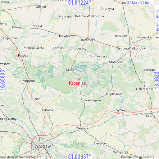
Krośnice GPS coordinates[2]
51° 28' 35.076" North, 17° 21' 33.012" East
| Map corner | latitude | longitude |
|---|---|---|
| Upper-left | 51.91224°, | 16.65605° |
| Center: | 51.47641°, | 17.35917° |
| Lower-right: | 51.03637°, | 18.0623° |
| Map W x H: | 97.4×97.4 km | = 60.5×60.5mi |
| max Lat: | 54.83135° ⇑44.1% North |
| Krośnice: | 51.47641° |
| min Lat: | ⇓55.9% South 49.21328° |
| min Long | Krośnice | max Long |
| 14.20249° | 17.35917° | 24.03723° |
| W 19%⇐ | ⇒81% E |
Elevation
Elevation of Krośnice is 137 m = 449 ft, and this is 54.4 m = 178 ft below average elevation for this country.
| Max E: |
974 m = 3196 ft | 63.7% |
| Avg. | 191.4 m = 628 ft | |
| Krośnice | 137 m = 449 ft | |
Min E: |
-3 m = -10 ft | 36.3% |
See also: Poland elevation on elevation.city.
Geographical zone
Krośnice is located in North temperate zone (between Tropic of Cancer and the Arctic Circle). Distance of this North polar circle is 1677.5 km =1042.3 mi to North.| Distance of | km | miles | from Krośnice |
|---|---|---|---|
| North Pole | 4283.4 | 2661.6 | to North |
| Arctic Circle | 1677.5 | 1042.3 | to North |
| Tropic Cancer | 3117.7 | 1937.2 | to South |
| Equator | 5723.6 | 3556.5 | to South |


Nearby cities:
15 places around Krośnice: (largest is in red/bold)
• Cielętniki
22.5 km =14 mi,  207°
207°
• Cieszków
17.2 km =10.7 mi,  359°
359°
• Dobroszyce
23.2 km =14.4 mi,  182°
182°
• Garki
20.8 km =12.9 mi,  70°
70°
• Jutrosin
23.3 km =14.5 mi,  325°
325°
• Krotoszyn
25.3 km =15.7 mi,  12°
12°
• Milicz
8.3 km =5.2 mi,  313°
313°
• Międzybórz
23.1 km =14.4 mi,  112°
112°
• Odolanów
24.4 km =15.2 mi,  63°
63°
• Sośnie
19 km =11.8 mi,  91°
91°
• Sulmierzyce
18.7 km =11.6 mi,  39°
39°
• Sułów
13.5 km =8.4 mi,  281°
281°
• Twardogóra
14.5 km =9 mi,  148°
148°
• Zawonia
21 km =13 mi, 212°
• Zduny
18.9 km =11.7 mi,  3°
3°
Sources, notices
• [Note1] Compared only with cities in Poland existing in our database
• [Src1] Map data: © OpenStreetMap contributors (CC-BY-SA)
• [Src2] Other city data from geonames.org with taken over terms of usage.
• [Src3] Geographical zone / Annual Mean Temperature by Robert A. Rohde @ Wikipedia
