Dębno Polskie geodata
Dębno Polskie (Greater Poland) is a populated place; located in Poland in Europe/Warsaw (GMT+2) time zone. With population of 620 people, there are 3226 cities with bigger population in this country. Compared to other cities in Poland, 57.5% of cities are located further ↓South; 86.3% of cities are located further →East and 81.8% of cities have higher elevation than Dębno Polskie. Note1


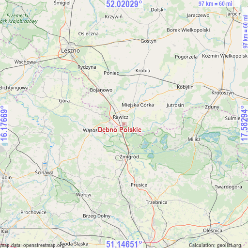
Dębno Polskie GPS coordinates[2]
51° 35' 7.8" North, 16° 52' 47.316" East
| Map corner | latitude | longitude |
|---|---|---|
| Upper-left | 52.02029°, | 16.17669° |
| Center: | 51.5855°, | 16.87981° |
| Lower-right: | 51.14651°, | 17.58294° |
| Map W x H: | 97.2×97.2 km | = 60.4×60.4mi |
| max Lat: | 54.83135° ⇑42.5% North |
| Dębno Polskie: | 51.5855° |
| min Lat: | ⇓57.5% South 49.21328° |
| min Long | Dębno Polskie | max Long |
| 14.20249° | 16.87981° | 24.03723° |
| W 13.7%⇐ | ⇒86.3% E |
Elevation
Elevation of Dębno Polskie is 96 m = 315 ft, and this is 95.4 m = 313 ft below average elevation for this country.
| Max E: |
974 m = 3196 ft | 81.8% |
| Avg. | 191.4 m = 628 ft | |
| Dębno Polskie | 96 m = 315 ft | |
Min E: |
-3 m = -10 ft | 18.2% |
See also: Poland elevation on elevation.city.
Geographical zone
Dębno Polskie is located in North temperate zone (between Tropic of Cancer and the Arctic Circle). Distance of this North polar circle is 1665.4 km =1034.8 mi to North.| Distance of | km | miles | from Dębno Polskie |
|---|---|---|---|
| North Pole | 4271.3 | 2654.1 | to North |
| Arctic Circle | 1665.4 | 1034.8 | to North |
| Tropic Cancer | 3129.9 | 1944.8 | to South |
| Equator | 5735.8 | 3564.1 | to South |


Nearby cities:
15 places around Dębno Polskie: (largest is in red/bold)
• Bojanowo
16.3 km =10.1 mi,  326°
326°
• Chojno
10 km =6.2 mi,  63°
63°
• Golina Wielka
14.4 km =8.9 mi, 332°
• Jutrosin
21.3 km =13.2 mi,  70°
70°
• Konary
13.7 km =8.5 mi,  54°
54°
• Krobia
22.1 km =13.7 mi,  18°
18°
• Miejska Górka
9.5 km =5.9 mi,  34°
34°
• Pakosław
12.7 km =7.9 mi,  75°
75°
• Poniec
20.4 km =12.7 mi,  346°
346°
• Rawicz
3 km =1.9 mi, 331°
• Sułów
22.1 km =13.7 mi,  115°
115°
• Szymanowo
2.4 km =1.5 mi, 22°
• Słupia Kapitulna
6 km =3.7 mi, 65°
• Wąsosz
13.3 km =8.3 mi,  258°
258°
• Żmigród
13.3 km =8.3 mi,  172°
172°
Sources, notices
• [Note1] Compared only with cities in Poland existing in our database
• [Src1] Map data: © OpenStreetMap contributors (CC-BY-SA)
• [Src2] Other city data from geonames.org with taken over terms of usage.
• [Src3] Geographical zone / Annual Mean Temperature by Robert A. Rohde @ Wikipedia
