Golina Wielka geodata
Golina Wielka (Greater Poland) is a populated place; located in Poland in Europe/Warsaw (GMT+2) time zone. With population of 797 people, there are 2869 cities with bigger population in this country. Compared to other cities in Poland, 60.1% of cities are located further ↓South; 87.5% of cities are located further →East and 78.8% of cities have higher elevation than Golina Wielka. Note1


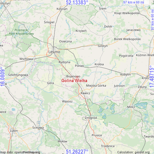
Golina Wielka GPS coordinates[2]
51° 42' 0.54" North, 16° 47' 2.472" East
| Map corner | latitude | longitude |
|---|---|---|
| Upper-left | 52.13383°, | 16.0809° |
| Center: | 51.70015°, | 16.78402° |
| Lower-right: | 51.26227°, | 17.48715° |
| Map W x H: | 96.9×96.9 km | = 60.2×60.2mi |
| max Lat: | 54.83135° ⇑39.9% North |
| Golina Wielka: | 51.70015° |
| min Lat: | ⇓60.1% South 49.21328° |
| min Long | Golina Wielka | max Long |
| 14.20249° | 16.78402° | 24.03723° |
| W 12.5%⇐ | ⇒87.5% E |
Elevation
Elevation of Golina Wielka is 102 m = 335 ft, and this is 89.4 m = 293 ft below average elevation for this country.
| Max E: |
974 m = 3196 ft | 78.8% |
| Avg. | 191.4 m = 628 ft | |
| Golina Wielka | 102 m = 335 ft | |
Min E: |
-3 m = -10 ft | 21.2% |
See also: Poland elevation on elevation.city.
Geographical zone
Golina Wielka is located in North temperate zone (between Tropic of Cancer and the Arctic Circle). Distance of this North polar circle is 1652.7 km =1026.9 mi to North.| Distance of | km | miles | from Golina Wielka |
|---|---|---|---|
| North Pole | 4258.5 | 2646.1 | to North |
| Arctic Circle | 1652.7 | 1026.9 | to North |
| Tropic Cancer | 3142.6 | 1952.7 | to South |
| Equator | 5748.5 | 3572 | to South |


Nearby cities:
15 places around Golina Wielka: (largest is in red/bold)
• Bojanowo
2.6 km =1.6 mi,  288°
288°
• Chojno
17.6 km =10.9 mi,  118°
118°
• Chróścina
17.5 km =10.9 mi, 286°
• Dębno Polskie
14.4 km =8.9 mi,  152°
152°
• Góra
17.6 km =10.9 mi,  257°
257°
• Konary
18.4 km =11.4 mi,  105°
105°
• Krobia
15.9 km =9.9 mi,  58°
58°
• Krzemieniewo
18 km =11.2 mi,  10°
10°
• Miejska Górka
13 km =8.1 mi, 112°
• Poniec
7.2 km =4.5 mi, 13°
• Rawicz
11.3 km =7 mi, 152°
• Rydzyna
12.5 km =7.8 mi,  320°
320°
• Szymanowo
13 km =8.1 mi,  144°
144°
• Słupia Kapitulna
15.8 km =9.8 mi,  130°
130°
• Wąsosz
16.6 km =10.3 mi,  202°
202°
Sources, notices
• [Note1] Compared only with cities in Poland existing in our database
• [Src1] Map data: © OpenStreetMap contributors (CC-BY-SA)
• [Src2] Other city data from geonames.org with taken over terms of usage.
• [Src3] Geographical zone / Annual Mean Temperature by Robert A. Rohde @ Wikipedia
