Szymanowo geodata
Szymanowo (Greater Poland) is a populated place; located in Poland in Europe/Warsaw (GMT+2) time zone. With population of 661 people, there are 3141 cities with bigger population in this country. Compared to other cities in Poland, 58.1% of cities are located further ↓South; 86% of cities are located further →East and 81.2% of cities have higher elevation than Szymanowo. Note1


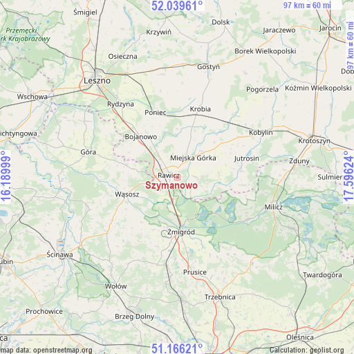
Szymanowo GPS coordinates[2]
51° 36' 18.036" North, 16° 53' 35.196" East
| Map corner | latitude | longitude |
|---|---|---|
| Upper-left | 52.03961°, | 16.18999° |
| Center: | 51.60501°, | 16.89311° |
| Lower-right: | 51.16621°, | 17.59624° |
| Map W x H: | 97.1×97.1 km | = 60.3×60.3mi |
| max Lat: | 54.83135° ⇑41.9% North |
| Szymanowo: | 51.60501° |
| min Lat: | ⇓58.1% South 49.21328° |
| min Long | Szymanowo | max Long |
| 14.20249° | 16.89311° | 24.03723° |
| W 14%⇐ | ⇒86% E |
Elevation
Elevation of Szymanowo is 97 m = 318 ft, and this is 94.4 m = 310 ft below average elevation for this country.
| Max E: |
974 m = 3196 ft | 81.2% |
| Avg. | 191.4 m = 628 ft | |
| Szymanowo | 97 m = 318 ft | |
Min E: |
-3 m = -10 ft | 18.8% |
See also: Poland elevation on elevation.city.
Geographical zone
Szymanowo is located in North temperate zone (between Tropic of Cancer and the Arctic Circle). Distance of this North polar circle is 1663.2 km =1033.5 mi to North.| Distance of | km | miles | from Szymanowo |
|---|---|---|---|
| North Pole | 4269.1 | 2652.7 | to North |
| Arctic Circle | 1663.2 | 1033.5 | to North |
| Tropic Cancer | 3132 | 1946.1 | to South |
| Equator | 5737.9 | 3565.4 | to South |


Nearby cities:
15 places around Szymanowo: (largest is in red/bold)
• Bojanowo
15.2 km =9.4 mi,  318°
318°
• Chojno
8.3 km =5.2 mi,  73°
73°
• Dębno Polskie
2.4 km =1.5 mi,  202°
202°
• Golina Wielka
13 km =8.1 mi, 324°
• Jutrosin
19.7 km =12.2 mi,  75°
75°
• Konary
11.8 km =7.3 mi,  60°
60°
• Krobia
19.8 km =12.3 mi,  18°
18°
• Miejska Górka
7.2 km =4.5 mi,  38°
38°
• Pakosław
11.4 km =7.1 mi, 84°
• Poniec
18.6 km =11.6 mi,  341°
341°
• Rawicz
2.4 km =1.5 mi,  281°
281°
• Sułów
22.3 km =13.9 mi,  121°
121°
• Słupia Kapitulna
4.6 km =2.9 mi,  85°
85°
• Wąsosz
14.8 km =9.2 mi,  251°
251°
• Żmigród
15.4 km =9.6 mi,  176°
176°
Sources, notices
• [Note1] Compared only with cities in Poland existing in our database
• [Src1] Map data: © OpenStreetMap contributors (CC-BY-SA)
• [Src2] Other city data from geonames.org with taken over terms of usage.
• [Src3] Geographical zone / Annual Mean Temperature by Robert A. Rohde @ Wikipedia
