Rawicz geodata
Rawicz (Greater Poland) is a seat of a second-order administrative division; located in Poland in Europe/Warsaw (GMT+2) time zone. With population of 21,380 people, there are 231 cities with bigger population in this country. Compared to other cities in Poland, 58.2% of cities are located further ↓South; 86.6% of cities are located further →East and 79.8% of cities have higher elevation than Rawicz. Note1


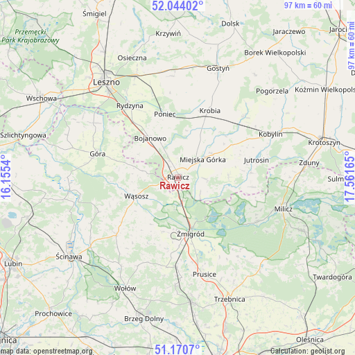
Rawicz GPS coordinates[2]
51° 36' 34.056" North, 16° 51' 30.672" East
| Map corner | latitude | longitude |
|---|---|---|
| Upper-left | 52.04402°, | 16.1554° |
| Center: | 51.60946°, | 16.85852° |
| Lower-right: | 51.1707°, | 17.56165° |
| Map W x H: | 97.1×97.1 km | = 60.3×60.3mi |
| max Lat: | 54.83135° ⇑41.8% North |
| Rawicz: | 51.60946° |
| min Lat: | ⇓58.2% South 49.21328° |
| min Long | Rawicz | max Long |
| 14.20249° | 16.85852° | 24.03723° |
| W 13.4%⇐ | ⇒86.6% E |
Elevation
Elevation of Rawicz is 100 m = 328 ft, and this is 91.4 m = 300 ft below average elevation for this country.
| Max E: |
974 m = 3196 ft | 79.8% |
| Avg. | 191.4 m = 628 ft | |
| Rawicz | 100 m = 328 ft | |
Min E: |
-3 m = -10 ft | 20.2% |
See also: Poland elevation on elevation.city.
Geographical zone
Rawicz is located in North temperate zone (between Tropic of Cancer and the Arctic Circle). Distance of this North polar circle is 1662.7 km =1033.2 mi to North.| Distance of | km | miles | from Rawicz |
|---|---|---|---|
| North Pole | 4268.6 | 2652.4 | to North |
| Arctic Circle | 1662.7 | 1033.2 | to North |
| Tropic Cancer | 3132.5 | 1946.4 | to South |
| Equator | 5738.4 | 3565.7 | to South |


Nearby cities:
15 places around Rawicz: (largest is in red/bold)
• Bojanowo
13.3 km =8.3 mi,  325°
325°
• Chojno
10.5 km =6.5 mi,  80°
80°
• Dębno Polskie
3 km =1.9 mi,  151°
151°
• Golina Wielka
11.3 km =7 mi, 332°
• Jutrosin
21.9 km =13.6 mi, 78°
• Konary
13.7 km =8.5 mi,  67°
67°
• Krobia
20.2 km =12.6 mi,  25°
25°
• Miejska Górka
8.6 km =5.3 mi,  53°
53°
• Pakosław
13.8 km =8.6 mi,  87°
87°
• Poniec
17.5 km =10.9 mi,  348°
348°
• Szymanowo
2.4 km =1.5 mi,  101°
101°
• Słupia Kapitulna
6.9 km =4.3 mi, 91°
• Wińsko
22.9 km =14.2 mi,  227°
227°
• Wąsosz
12.7 km =7.9 mi,  245°
245°
• Żmigród
16.2 km =10.1 mi,  168°
168°
Sources, notices
• [Note1] Compared only with cities in Poland existing in our database
• [Src1] Map data: © OpenStreetMap contributors (CC-BY-SA)
• [Src2] Other city data from geonames.org with taken over terms of usage.
• [Src3] Geographical zone / Annual Mean Temperature by Robert A. Rohde @ Wikipedia
