Budziska geodata
Budziska (Silesia) is a populated place; located in Poland in Europe/Warsaw (GMT+2) time zone. With population of 846 people, there are 2777 cities with bigger population in this country. Compared to other cities in Poland, 74.3% of cities are located further ↑North; 71.6% of cities are located further →East and 53.5% of cities have lower elevation than Budziska. Note1


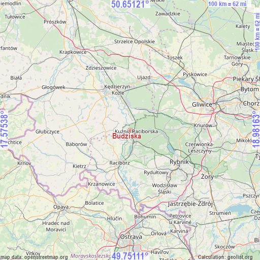
Budziska GPS coordinates[2]
50° 12' 11.808" North, 18° 16' 42.6" East
| Map corner | latitude | longitude |
|---|---|---|
| Upper-left | 50.65121°, | 17.57538° |
| Center: | 50.20328°, | 18.2785° |
| Lower-right: | 49.75111°, | 18.98163° |
| Map W x H: | 100.1×100.1 km | = 62.2×62.2mi |
| max Lat: | 54.83135° ⇑74.3% North |
| Budziska: | 50.20328° |
| min Lat: | ⇓25.7% South 49.21328° |
| min Long | Budziska | max Long |
| 14.20249° | 18.2785° | 24.03723° |
| W 28.4%⇐ | ⇒71.6% E |
Elevation
Elevation of Budziska is 181 m = 594 ft, and this is 10.4 m = 34 ft below average elevation for this country.
| Max E: |
974 m = 3196 ft | 46.5% |
| Avg. | 191.4 m = 628 ft | |
| Budziska | 181 m = 594 ft | |
Min E: |
-3 m = -10 ft | 53.5% |
See also: Poland elevation on elevation.city.
Geographical zone
Budziska is located in North temperate zone (between Tropic of Cancer and the Arctic Circle). Distance of this North polar circle is 1819.1 km =1130.3 mi to North.| Distance of | km | miles | from Budziska |
|---|---|---|---|
| North Pole | 4425 | 2749.6 | to North |
| Arctic Circle | 1819.1 | 1130.3 | to North |
| Tropic Cancer | 2976.2 | 1849.3 | to South |
| Equator | 5582.1 | 3468.6 | to South |


Nearby cities:
15 places around Budziska: (largest is in red/bold)
• Adamowice
8.8 km =5.5 mi,  153°
153°
• Babice
6.9 km =4.3 mi,  168°
168°
• Bierawa
9 km =5.6 mi,  343°
343°
• Bogunice
9.7 km =6 mi,  138°
138°
• Brzeźnica
7.4 km =4.6 mi,  213°
213°
• Cisek
10.4 km =6.5 mi,  327°
327°
• Dziergowice
4.4 km =2.7 mi,  7°
7°
• Górki Śląskie
10.4 km =6.5 mi,  131°
131°
• Kuźnia Raciborska
2.4 km =1.5 mi,  97°
97°
• Lubieszów
6.4 km =4 mi,  352°
352°
• Nędza
5.2 km =3.2 mi, 153°
• Polska Cerekiew
11.1 km =6.9 mi,  284°
284°
• Raszczyce
9.2 km =5.7 mi, 170°
• Rudnik
10.7 km =6.6 mi,  217°
217°
• Turze
1.5 km =0.9 mi, 221°
Sources, notices
• [Note1] Compared only with cities in Poland existing in our database
• [Src1] Map data: © OpenStreetMap contributors (CC-BY-SA)
• [Src2] Other city data from geonames.org with taken over terms of usage.
• [Src3] Geographical zone / Annual Mean Temperature by Robert A. Rohde @ Wikipedia
