Brzeźnica geodata
Brzeźnica (Silesia) is a populated place; located in Poland in Europe/Warsaw (GMT+2) time zone. With population of 597 people, there are 3294 cities with bigger population in this country. Compared to other cities in Poland, 76.1% of cities are located further ↑North; 72.2% of cities are located further →East and 59.4% of cities have lower elevation than Brzeźnica. Note1


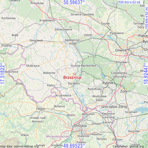
Brzeźnica GPS coordinates[2]
50° 8' 52.512" North, 18° 13' 16.824" East
| Map corner | latitude | longitude |
|---|---|---|
| Upper-left | 50.59637°, | 17.51822° |
| Center: | 50.14792°, | 18.22134° |
| Lower-right: | 49.69523°, | 18.92447° |
| Map W x H: | 100.2×100.2 km | = 62.3×62.3mi |
| max Lat: | 54.83135° ⇑76.1% North |
| Brzeźnica: | 50.14792° |
| min Lat: | ⇓23.9% South 49.21328° |
| min Long | Brzeźnica | max Long |
| 14.20249° | 18.22134° | 24.03723° |
| W 27.8%⇐ | ⇒72.2% E |
Elevation
Elevation of Brzeźnica is 199 m = 653 ft, and this is 7.6 m = 25 ft above average elevation for this country.
| Max E: |
974 m = 3196 ft | 40.6% |
| Brzeźnica | 199 m 653 ft | |
| Avg. | 191.4 m = 628 ft | |
Min E: |
-3 m = -10 ft | 59.4% |
See also: Poland elevation on elevation.city.
Geographical zone
Brzeźnica is located in North temperate zone (between Tropic of Cancer and the Arctic Circle). Distance of this North polar circle is 1825.2 km =1134.1 mi to North.| Distance of | km | miles | from Brzeźnica |
|---|---|---|---|
| North Pole | 4431.1 | 2753.4 | to North |
| Arctic Circle | 1825.2 | 1134.1 | to North |
| Tropic Cancer | 2970 | 1845.5 | to South |
| Equator | 5575.9 | 3464.7 | to South |


Nearby cities:
15 places around Brzeźnica: (largest is in red/bold)
• Adamowice
8.1 km =5 mi,  102°
102°
• Babice
5.4 km =3.4 mi, 96°
• Bogunice
10.5 km =6.5 mi, 95°
• Budziska
7.4 km =4.6 mi,  33°
33°
• Kobyła
8.6 km =5.3 mi,  136°
136°
• Kuźnia Raciborska
8.7 km =5.4 mi,  47°
47°
• Maków
10.8 km =6.7 mi,  246°
246°
• Nędza
6.6 km =4.1 mi,  77°
77°
• Pawłów
7.8 km =4.8 mi,  238°
238°
• Pogrzebień
10.5 km =6.5 mi,  148°
148°
• Polska Cerekiew
11.2 km =7 mi,  322°
322°
• Racibórz
6.2 km =3.9 mi,  181°
181°
• Raszczyce
6.3 km =3.9 mi,  117°
117°
• Rudnik
3.4 km =2.1 mi,  227°
227°
• Turze
5.9 km =3.7 mi, 31°
Sources, notices
• [Note1] Compared only with cities in Poland existing in our database
• [Src1] Map data: © OpenStreetMap contributors (CC-BY-SA)
• [Src2] Other city data from geonames.org with taken over terms of usage.
• [Src3] Geographical zone / Annual Mean Temperature by Robert A. Rohde @ Wikipedia
