Dziergowice geodata
Dziergowice (Opole Voivodeship) is a populated place; located in Poland in Europe/Warsaw (GMT+2) time zone. With population of 2,556 people, there are 1221 cities with bigger population in this country. Compared to other cities in Poland, 73.4% of cities are located further ↑North; 71.6% of cities are located further →East and 55% of cities have lower elevation than Dziergowice. Note1
Administrative division(s):
- Level 1: Opole Voivodeship
- Level 2: Powiat kędzierzyńsko-kozielski
- Level 3: Bierawa


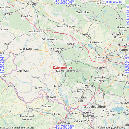
Dziergowice GPS coordinates[2]
50° 14' 32.928" North, 18° 17' 9.816" East
| Map corner | latitude | longitude |
|---|---|---|
| Upper-left | 50.69004°, | 17.58294° |
| Center: | 50.24248°, | 18.28606° |
| Lower-right: | 49.79068°, | 18.98919° |
| Map W x H: | 100×100 km | = 62.1×62.1mi |
| max Lat: | 54.83135° ⇑73.4% North |
| Dziergowice: | 50.24248° |
| min Lat: | ⇓26.6% South 49.21328° |
| min Long | Dziergowice | max Long |
| 14.20249° | 18.28606° | 24.03723° |
| W 28.4%⇐ | ⇒71.6% E |
Elevation
Elevation of Dziergowice is 185 m = 607 ft, and this is 6.4 m = 21 ft below average elevation for this country.
| Max E: |
974 m = 3196 ft | 45% |
| Avg. | 191.4 m = 628 ft | |
| Dziergowice | 185 m = 607 ft | |
Min E: |
-3 m = -10 ft | 55% |
See also: Poland elevation on elevation.city.
Geographical zone
Dziergowice is located in North temperate zone (between Tropic of Cancer and the Arctic Circle). Distance of this North polar circle is 1814.7 km =1127.6 mi to North.| Distance of | km | miles | from Dziergowice |
|---|---|---|---|
| North Pole | 4420.6 | 2746.8 | to North |
| Arctic Circle | 1814.7 | 1127.6 | to North |
| Tropic Cancer | 2980.5 | 1852 | to South |
| Equator | 5586.4 | 3471.2 | to South |


Nearby cities:
15 places around Dziergowice: (largest is in red/bold)
• Adamowice
12.7 km =7.9 mi,  164°
164°
• Babice
11.1 km =6.9 mi,  175°
175°
• Bierawa
5.3 km =3.3 mi,  323°
323°
• Bogunice
13 km =8.1 mi,  153°
153°
• Brzeźnica
11.5 km =7.1 mi,  203°
203°
• Budziska
4.4 km =2.7 mi,  187°
187°
• Cisek
7.6 km =4.7 mi,  305°
305°
• Długomiłowice
10.8 km =6.7 mi,  294°
294°
• Kuźnia Raciborska
5 km =3.1 mi, 158°
• Kędzierzyn-Koźle
12.7 km =7.9 mi,  340°
340°
• Lubieszów
2.4 km =1.5 mi, 324°
• Nędza
9.2 km =5.7 mi,  168°
168°
• Polska Cerekiew
11.4 km =7.1 mi,  262°
262°
• Rudy
13.3 km =8.3 mi,  116°
116°
• Turze
5.6 km =3.5 mi, 195°
Sources, notices
• [Note1] Compared only with cities in Poland existing in our database
• [Src1] Map data: © OpenStreetMap contributors (CC-BY-SA)
• [Src2] Other city data from geonames.org with taken over terms of usage.
• [Src3] Geographical zone / Annual Mean Temperature by Robert A. Rohde @ Wikipedia
