Rudnik geodata
Rudnik (Silesia) is a seat of a third-order administrative division; located in Poland in Europe/Warsaw (GMT+2) time zone. With population of 916 people, there are 2650 cities with bigger population in this country. Compared to other cities in Poland, 77% of cities are located further ↑North; 72.8% of cities are located further →East and 61.5% of cities have lower elevation than Rudnik. Note1


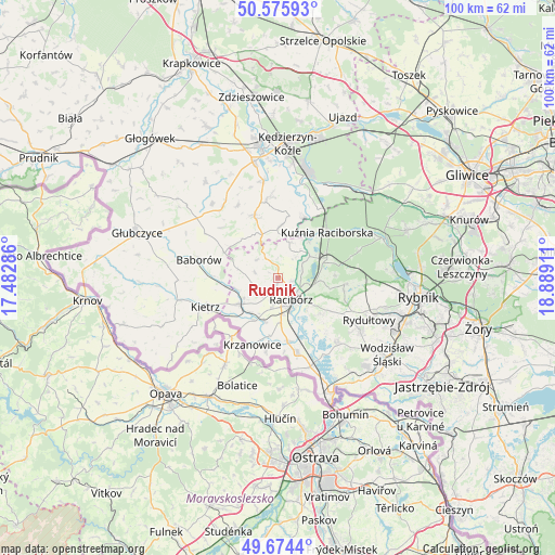
Rudnik GPS coordinates[2]
50° 7' 38.244" North, 18° 11' 9.528" East
| Map corner | latitude | longitude |
|---|---|---|
| Upper-left | 50.57593°, | 17.48286° |
| Center: | 50.12729°, | 18.18598° |
| Lower-right: | 49.6744°, | 18.88911° |
| Map W x H: | 100.2×100.2 km | = 62.3×62.3mi |
| max Lat: | 54.83135° ⇑77% North |
| Rudnik: | 50.12729° |
| min Lat: | ⇓23% South 49.21328° |
| min Long | Rudnik | max Long |
| 14.20249° | 18.18598° | 24.03723° |
| W 27.2%⇐ | ⇒72.8% E |
Elevation
Elevation of Rudnik is 204 m = 669 ft, and this is 12.6 m = 41 ft above average elevation for this country.
| Max E: |
974 m = 3196 ft | 38.5% |
| Rudnik | 204 m 669 ft | |
| Avg. | 191.4 m = 628 ft | |
Min E: |
-3 m = -10 ft | 61.5% |
See also: Poland elevation on elevation.city.
Geographical zone
Rudnik is located in North temperate zone (between Tropic of Cancer and the Arctic Circle). Distance of this North polar circle is 1827.5 km =1135.6 mi to North.| Distance of | km | miles | from Rudnik |
|---|---|---|---|
| North Pole | 4433.4 | 2754.8 | to North |
| Arctic Circle | 1827.5 | 1135.6 | to North |
| Tropic Cancer | 2967.7 | 1844 | to South |
| Equator | 5573.6 | 3463.3 | to South |


Nearby cities:
15 places around Rudnik: (largest is in red/bold)
• Adamowice
10.5 km =6.5 mi,  87°
87°
• Babice
8.1 km =5 mi,  77°
77°
• Bojanów
11 km =6.8 mi,  187°
187°
• Brzeźnica
3.4 km =2.1 mi,  47°
47°
• Budziska
10.7 km =6.6 mi,  37°
37°
• Kobyła
9.3 km =5.8 mi,  114°
114°
• Maków
7.6 km =4.7 mi,  254°
254°
• Nieboczowy
10.7 km =6.6 mi,  150°
150°
• Nędza
9.7 km =6 mi,  67°
67°
• Pawłów
4.5 km =2.8 mi, 246°
• Pietrowice Wielkie
8.2 km =5.1 mi,  234°
234°
• Pogrzebień
10.5 km =6.5 mi,  129°
129°
• Racibórz
4.6 km =2.9 mi, 148°
• Raszczyce
8.1 km =5 mi, 94°
• Turze
9.3 km =5.8 mi, 37°
Sources, notices
• [Note1] Compared only with cities in Poland existing in our database
• [Src1] Map data: © OpenStreetMap contributors (CC-BY-SA)
• [Src2] Other city data from geonames.org with taken over terms of usage.
• [Src3] Geographical zone / Annual Mean Temperature by Robert A. Rohde @ Wikipedia
