Brzeźnio geodata
Brzeźnio (Łódź Voivodeship) is a seat of a third-order administrative division; located in Poland in Europe/Warsaw (GMT+2) time zone. With population of 1,150 people, there are 2258 cities with bigger population in this country. Compared to other cities in Poland, 56.1% of cities are located further ↓South; 66.2% of cities are located further →East and 51.3% of cities have higher elevation than Brzeźnio. Note1


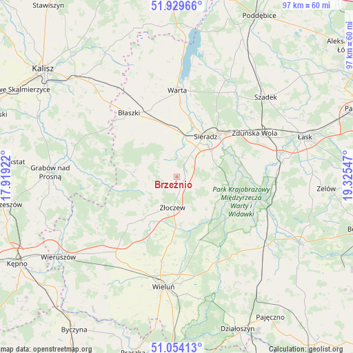
Brzeźnio GPS coordinates[2]
51° 29' 38.4" North, 18° 37' 20.424" East
| Map corner | latitude | longitude |
|---|---|---|
| Upper-left | 51.92966°, | 17.91922° |
| Center: | 51.494°, | 18.62234° |
| Lower-right: | 51.05413°, | 19.32547° |
| Map W x H: | 97.3×97.3 km | = 60.5×60.5mi |
| max Lat: | 54.83135° ⇑43.9% North |
| Brzeźnio: | 51.494° |
| min Lat: | ⇓56.1% South 49.21328° |
| min Long | Brzeźnio | max Long |
| 14.20249° | 18.62234° | 24.03723° |
| W 33.8%⇐ | ⇒66.2% E |
Elevation
Elevation of Brzeźnio is 169 m = 554 ft, and this is 22.4 m = 73 ft below average elevation for this country.
| Max E: |
974 m = 3196 ft | 51.3% |
| Avg. | 191.4 m = 628 ft | |
| Brzeźnio | 169 m = 554 ft | |
Min E: |
-3 m = -10 ft | 48.7% |
See also: Poland elevation on elevation.city.
Geographical zone
Brzeźnio is located in North temperate zone (between Tropic of Cancer and the Arctic Circle). Distance of this North polar circle is 1675.6 km =1041.2 mi to North.| Distance of | km | miles | from Brzeźnio |
|---|---|---|---|
| North Pole | 4281.5 | 2660.4 | to North |
| Arctic Circle | 1675.6 | 1041.2 | to North |
| Tropic Cancer | 3119.7 | 1938.5 | to South |
| Equator | 5725.6 | 3557.7 | to South |


Nearby cities:
15 places around Brzeźnio: (largest is in red/bold)
• Borysławice
22.2 km =13.8 mi,  322°
322°
• Brąszewice
12 km =7.5 mi,  272°
272°
• Burzenin
15 km =9.3 mi,  104°
104°
• Błaszki
21.8 km =13.5 mi, 323°
• Czajków
20.4 km =12.7 mi, 269°
• Czarnożyły
23.6 km =14.7 mi,  190°
190°
• Klonowa
16.4 km =10.2 mi,  239°
239°
• Konopnica
20.9 km =13 mi,  138°
138°
• Lututów
18.9 km =11.7 mi,  223°
223°
• Ostrówek
17.5 km =10.9 mi,  179°
179°
• Sieradz
13.6 km =8.5 mi,  33°
33°
• Widawa
23.1 km =14.4 mi,  105°
105°
• Wróblew
13.1 km =8.1 mi,  357°
357°
• Zapolice
18.9 km =11.7 mi,  73°
73°
• Złoczew
8.6 km =5.3 mi, 188°
Sources, notices
• [Note1] Compared only with cities in Poland existing in our database
• [Src1] Map data: © OpenStreetMap contributors (CC-BY-SA)
• [Src2] Other city data from geonames.org with taken over terms of usage.
• [Src3] Geographical zone / Annual Mean Temperature by Robert A. Rohde @ Wikipedia
