Wróblew geodata
Wróblew (Łódź Voivodeship) is a seat of a third-order administrative division; located in Poland in Europe/Warsaw (GMT+2) time zone. With population of 340 people, there are 3610 cities with bigger population in this country. Compared to other cities in Poland, 58.2% of cities are located further ↓South; 66.4% of cities are located further →East and 57.6% of cities have higher elevation than Wróblew. Note1


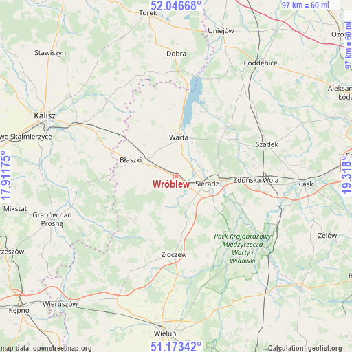
Wróblew GPS coordinates[2]
51° 36' 43.74" North, 18° 36' 53.532" East
| Map corner | latitude | longitude |
|---|---|---|
| Upper-left | 52.04668°, | 17.91175° |
| Center: | 51.61215°, | 18.61487° |
| Lower-right: | 51.17342°, | 19.318° |
| Map W x H: | 97.1×97.1 km | = 60.3×60.3mi |
| max Lat: | 54.83135° ⇑41.8% North |
| Wróblew: | 51.61215° |
| min Lat: | ⇓58.2% South 49.21328° |
| min Long | Wróblew | max Long |
| 14.20249° | 18.61487° | 24.03723° |
| W 33.6%⇐ | ⇒66.4% E |
Elevation
Elevation of Wróblew is 152 m = 499 ft, and this is 39.4 m = 129 ft below average elevation for this country.
| Max E: |
974 m = 3196 ft | 57.6% |
| Avg. | 191.4 m = 628 ft | |
| Wróblew | 152 m = 499 ft | |
Min E: |
-3 m = -10 ft | 42.4% |
See also: Poland elevation on elevation.city.
Geographical zone
Wróblew is located in North temperate zone (between Tropic of Cancer and the Arctic Circle). Distance of this North polar circle is 1662.4 km =1033 mi to North.| Distance of | km | miles | from Wróblew |
|---|---|---|---|
| North Pole | 4268.3 | 2652.2 | to North |
| Arctic Circle | 1662.4 | 1033 | to North |
| Tropic Cancer | 3132.8 | 1946.6 | to South |
| Equator | 5738.7 | 3565.9 | to South |


Nearby cities:
15 places around Wróblew: (largest is in red/bold)
• Borysławice
13.7 km =8.5 mi,  289°
289°
• Brzeźnio
13.1 km =8.1 mi,  177°
177°
• Brąszewice
17 km =10.6 mi,  222°
222°
• Burzenin
22.6 km =14 mi,  138°
138°
• Błaszki
13.2 km =8.2 mi, 289°
• Czajków
24 km =14.9 mi,  236°
236°
• Goszczanów
21.3 km =13.2 mi,  339°
339°
• Pęczniew
22.6 km =14 mi,  19°
19°
• Sieradz
8.2 km =5.1 mi,  102°
102°
• Szczytniki
21.3 km =13.2 mi, 293°
• Warta
11 km =6.8 mi,  3°
3°
• Wojsławice
21.8 km =13.5 mi,  78°
78°
• Zapolice
20.1 km =12.5 mi,  112°
112°
• Zduńska Wola
22.5 km =14 mi,  93°
93°
• Złoczew
21.7 km =13.5 mi, 182°
Sources, notices
• [Note1] Compared only with cities in Poland existing in our database
• [Src1] Map data: © OpenStreetMap contributors (CC-BY-SA)
• [Src2] Other city data from geonames.org with taken over terms of usage.
• [Src3] Geographical zone / Annual Mean Temperature by Robert A. Rohde @ Wikipedia
