Czarnożyły geodata
Czarnożyły (Łódź Voivodeship) is a populated place; located in Poland in Europe/Warsaw (GMT+2) time zone. With population of 1,300 people, there are 2055 cities with bigger population in this country. Compared to other cities in Poland, 52.8% of cities are located further ↓South; 67.3% of cities are located further →East and 56% of cities have lower elevation than Czarnożyły. Note1


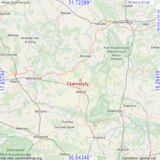
Czarnożyły GPS coordinates[2]
51° 17' 7.188" North, 18° 33' 39.816" East
| Map corner | latitude | longitude |
|---|---|---|
| Upper-left | 51.72299°, | 17.85794° |
| Center: | 51.28533°, | 18.56106° |
| Lower-right: | 50.84346°, | 19.26419° |
| Map W x H: | 97.8×97.8 km | = 60.8×60.8mi |
| max Lat: | 54.83135° ⇑47.2% North |
| Czarnożyły: | 51.28533° |
| min Lat: | ⇓52.8% South 49.21328° |
| min Long | Czarnożyły | max Long |
| 14.20249° | 18.56106° | 24.03723° |
| W 32.7%⇐ | ⇒67.3% E |
Elevation
Elevation of Czarnożyły is 188 m = 617 ft, and this is 3.4 m = 11 ft below average elevation for this country.
| Max E: |
974 m = 3196 ft | 44% |
| Avg. | 191.4 m = 628 ft | |
| Czarnożyły | 188 m = 617 ft | |
Min E: |
-3 m = -10 ft | 56% |
See also: Poland elevation on elevation.city.
Geographical zone
Czarnożyły is located in North temperate zone (between Tropic of Cancer and the Arctic Circle). Distance of this North polar circle is 1698.8 km =1055.6 mi to North.| Distance of | km | miles | from Czarnożyły |
|---|---|---|---|
| North Pole | 4304.7 | 2674.8 | to North |
| Arctic Circle | 1698.8 | 1055.6 | to North |
| Tropic Cancer | 3096.5 | 1924.1 | to South |
| Equator | 5702.4 | 3543.3 | to South |


Nearby cities:
15 places around Czarnożyły: (largest is in red/bold)
• Czastary
17.1 km =10.6 mi,  260°
260°
• Klonowa
17.9 km =11.1 mi,  326°
326°
• Lututów
12.9 km =8 mi,  317°
317°
• Masłowice
6.2 km =3.9 mi,  120°
120°
• Mokrsko
12.9 km =8 mi,  203°
203°
• Osjaków
16 km =9.9 mi,  88°
88°
• Ostrówek
7.1 km =4.4 mi,  37°
37°
• Ożarów
16 km =9.9 mi,  192°
192°
• Pątnów
16.2 km =10.1 mi,  166°
166°
• Skomlin
17.6 km =10.9 mi,  223°
223°
• Sokolniki
16.1 km =10 mi,  278°
278°
• Walichnowy
12.6 km =7.8 mi, 275°
• Wieluń
7.2 km =4.5 mi,  175°
175°
• Wierzchlas
11.6 km =7.2 mi,  141°
141°
• Złoczew
15 km =9.3 mi,  11°
11°
Sources, notices
• [Note1] Compared only with cities in Poland existing in our database
• [Src1] Map data: © OpenStreetMap contributors (CC-BY-SA)
• [Src2] Other city data from geonames.org with taken over terms of usage.
• [Src3] Geographical zone / Annual Mean Temperature by Robert A. Rohde @ Wikipedia
