Klonowa geodata
Klonowa (Łódź Voivodeship) is a seat of a third-order administrative division; located in Poland in Europe/Warsaw (GMT+2) time zone. With population of 950 people, there are 2592 cities with bigger population in this country. Compared to other cities in Poland, 55.2% of cities are located further ↓South; 69.4% of cities are located further →East and 53.3% of cities have higher elevation than Klonowa. Note1


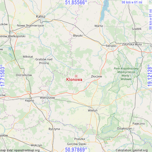
Klonowa GPS coordinates[2]
51° 25' 9.408" North, 18° 25' 5.34" East
| Map corner | latitude | longitude |
|---|---|---|
| Upper-left | 51.85566°, | 17.71503° |
| Center: | 51.41928°, | 18.41815° |
| Lower-right: | 50.97869°, | 19.12128° |
| Map W x H: | 97.5×97.5 km | = 60.6×60.6mi |
| max Lat: | 54.83135° ⇑44.8% North |
| Klonowa: | 51.41928° |
| min Lat: | ⇓55.2% South 49.21328° |
| min Long | Klonowa | max Long |
| 14.20249° | 18.41815° | 24.03723° |
| W 30.6%⇐ | ⇒69.4% E |
Elevation
Elevation of Klonowa is 163 m = 535 ft, and this is 28.4 m = 93 ft below average elevation for this country.
| Max E: |
974 m = 3196 ft | 53.3% |
| Avg. | 191.4 m = 628 ft | |
| Klonowa | 163 m = 535 ft | |
Min E: |
-3 m = -10 ft | 46.7% |
See also: Poland elevation on elevation.city.
Geographical zone
Klonowa is located in North temperate zone (between Tropic of Cancer and the Arctic Circle). Distance of this North polar circle is 1683.9 km =1046.3 mi to North.| Distance of | km | miles | from Klonowa |
|---|---|---|---|
| North Pole | 4289.8 | 2665.6 | to North |
| Arctic Circle | 1683.9 | 1046.3 | to North |
| Tropic Cancer | 3111.4 | 1933.3 | to South |
| Equator | 5717.3 | 3552.6 | to South |


Nearby cities:
15 places around Klonowa: (largest is in red/bold)
• Brzeziny
22.6 km =14 mi,  330°
330°
• Brzeźnio
16.4 km =10.2 mi,  59°
59°
• Brąszewice
9.1 km =5.7 mi,  13°
13°
• Czajków
10.2 km =6.3 mi,  322°
322°
• Czarnożyły
17.9 km =11.1 mi,  146°
146°
• Czastary
19.1 km =11.9 mi,  200°
200°
• Galewice
13.9 km =8.6 mi,  233°
233°
• Grabów nad Prosną
22.8 km =14.2 mi,  294°
294°
• Kraszewice
17.6 km =10.9 mi,  308°
308°
• Lututów
5.6 km =3.5 mi,  168°
168°
• Osiek
16.2 km =10.1 mi,  249°
249°
• Ostrówek
17 km =10.6 mi,  122°
122°
• Sokolniki
13.8 km =8.6 mi,  205°
205°
• Walichnowy
14 km =8.7 mi,  190°
190°
• Złoczew
12.9 km =8 mi,  91°
91°
Sources, notices
• [Note1] Compared only with cities in Poland existing in our database
• [Src1] Map data: © OpenStreetMap contributors (CC-BY-SA)
• [Src2] Other city data from geonames.org with taken over terms of usage.
• [Src3] Geographical zone / Annual Mean Temperature by Robert A. Rohde @ Wikipedia
