Czajków geodata
Czajków (Greater Poland) is a seat of a third-order administrative division; located in Poland in Europe/Warsaw (GMT+2) time zone. With population of 1,100 people, there are 2307 cities with bigger population in this country. Compared to other cities in Poland, 56.1% of cities are located further ↓South; 70.9% of cities are located further →East and 60.3% of cities have higher elevation than Czajków. Note1


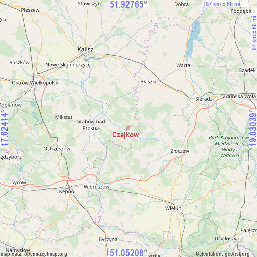
Czajków GPS coordinates[2]
51° 29' 31.092" North, 18° 19' 38.136" East
| Map corner | latitude | longitude |
|---|---|---|
| Upper-left | 51.92765°, | 17.62414° |
| Center: | 51.49197°, | 18.32726° |
| Lower-right: | 51.05208°, | 19.03039° |
| Map W x H: | 97.4×97.4 km | = 60.5×60.5mi |
| max Lat: | 54.83135° ⇑43.9% North |
| Czajków: | 51.49197° |
| min Lat: | ⇓56.1% South 49.21328° |
| min Long | Czajków | max Long |
| 14.20249° | 18.32726° | 24.03723° |
| W 29.1%⇐ | ⇒70.9% E |
Elevation
Elevation of Czajków is 146 m = 479 ft, and this is 45.4 m = 149 ft below average elevation for this country.
| Max E: |
974 m = 3196 ft | 60.3% |
| Avg. | 191.4 m = 628 ft | |
| Czajków | 146 m = 479 ft | |
Min E: |
-3 m = -10 ft | 39.7% |
See also: Poland elevation on elevation.city.
Geographical zone
Czajków is located in North temperate zone (between Tropic of Cancer and the Arctic Circle). Distance of this North polar circle is 1675.8 km =1041.3 mi to North.| Distance of | km | miles | from Czajków |
|---|---|---|---|
| North Pole | 4281.7 | 2660.5 | to North |
| Arctic Circle | 1675.8 | 1041.3 | to North |
| Tropic Cancer | 3119.5 | 1938.4 | to South |
| Equator | 5725.4 | 3557.6 | to South |


Nearby cities:
15 places around Czajków: (largest is in red/bold)
• Borysławice
19.2 km =11.9 mi,  21°
21°
• Brzeziny
12.6 km =7.8 mi,  336°
336°
• Brzeźnio
20.4 km =12.7 mi,  89°
89°
• Brąszewice
8.5 km =5.3 mi,  84°
84°
• Błaszki
19.2 km =11.9 mi, 22°
• Doruchów
19.2 km =11.9 mi,  244°
244°
• Galewice
17.1 km =10.6 mi,  196°
196°
• Godziesze Wielkie
20.1 km =12.5 mi,  327°
327°
• Grabów nad Prosną
14.5 km =9 mi,  276°
276°
• Klonowa
10.2 km =6.3 mi,  142°
142°
• Kraszewice
8 km =5 mi,  291°
291°
• Lututów
15.4 km =9.6 mi,  151°
151°
• Osiek
16.4 km =10.2 mi,  212°
212°
• Sokolniki
20.5 km =12.7 mi,  178°
178°
• Złoczew
20.9 km =13 mi,  113°
113°
Sources, notices
• [Note1] Compared only with cities in Poland existing in our database
• [Src1] Map data: © OpenStreetMap contributors (CC-BY-SA)
• [Src2] Other city data from geonames.org with taken over terms of usage.
• [Src3] Geographical zone / Annual Mean Temperature by Robert A. Rohde @ Wikipedia
