Ostrówek geodata
Ostrówek (Łódź Voivodeship) is a populated place; located in Poland in Europe/Warsaw (GMT+2) time zone. With population of 520 people, there are 3482 cities with bigger population in this country. Compared to other cities in Poland, 53.8% of cities are located further ↓South; 66.1% of cities are located further →East and 51.5% of cities have lower elevation than Ostrówek. Note1


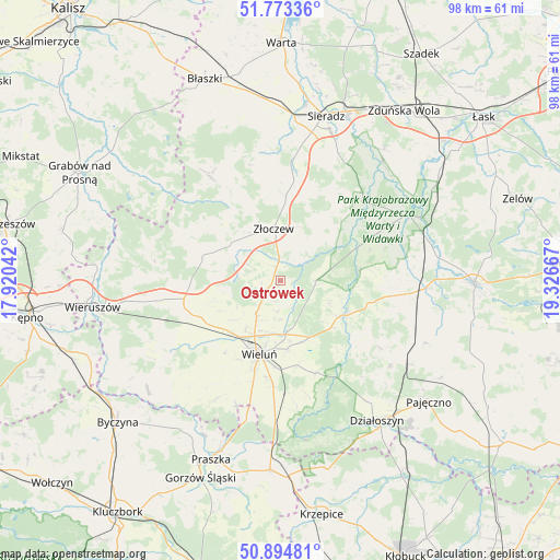
Ostrówek GPS coordinates[2]
51° 20' 10.284" North, 18° 37' 24.744" East
| Map corner | latitude | longitude |
|---|---|---|
| Upper-left | 51.77336°, | 17.92042° |
| Center: | 51.33619°, | 18.62354° |
| Lower-right: | 50.89481°, | 19.32667° |
| Map W x H: | 97.7×97.7 km | = 60.7×60.7mi |
| max Lat: | 54.83135° ⇑46.2% North |
| Ostrówek: | 51.33619° |
| min Lat: | ⇓53.8% South 49.21328° |
| min Long | Ostrówek | max Long |
| 14.20249° | 18.62354° | 24.03723° |
| W 33.9%⇐ | ⇒66.1% E |
Elevation
Elevation of Ostrówek is 176 m = 577 ft, and this is 15.4 m = 51 ft below average elevation for this country.
| Max E: |
974 m = 3196 ft | 48.5% |
| Avg. | 191.4 m = 628 ft | |
| Ostrówek | 176 m = 577 ft | |
Min E: |
-3 m = -10 ft | 51.5% |
See also: Poland elevation on elevation.city.
Geographical zone
Ostrówek is located in North temperate zone (between Tropic of Cancer and the Arctic Circle). Distance of this North polar circle is 1693.1 km =1052 mi to North.| Distance of | km | miles | from Ostrówek |
|---|---|---|---|
| North Pole | 4299 | 2671.3 | to North |
| Arctic Circle | 1693.1 | 1052 | to North |
| Tropic Cancer | 3102.1 | 1927.6 | to South |
| Equator | 5708 | 3546.8 | to South |


Nearby cities:
15 places around Ostrówek: (largest is in red/bold)
• Brzeźnio
17.5 km =10.9 mi,  359°
359°
• Burzenin
20 km =12.4 mi,  46°
46°
• Czarnożyły
7.1 km =4.4 mi,  217°
217°
• Klonowa
17 km =10.6 mi,  302°
302°
• Konopnica
14 km =8.7 mi,  81°
81°
• Lipnik
20.5 km =12.7 mi,  123°
123°
• Lututów
13.6 km =8.5 mi,  286°
286°
• Masłowice
8.9 km =5.5 mi,  173°
173°
• Mokrsko
19.8 km =12.3 mi,  208°
208°
• Osjaków
12.8 km =8 mi,  113°
113°
• Sokolniki
20.5 km =12.7 mi,  260°
260°
• Walichnowy
17.5 km =10.9 mi, 255°
• Wieluń
13.3 km =8.3 mi,  196°
196°
• Wierzchlas
14.9 km =9.3 mi, 168°
• Złoczew
9.1 km =5.7 mi,  351°
351°
Sources, notices
• [Note1] Compared only with cities in Poland existing in our database
• [Src1] Map data: © OpenStreetMap contributors (CC-BY-SA)
• [Src2] Other city data from geonames.org with taken over terms of usage.
• [Src3] Geographical zone / Annual Mean Temperature by Robert A. Rohde @ Wikipedia
