Pawłów geodata
Pawłów (Silesia) is a populated place; located in Poland in Europe/Warsaw (GMT+2) time zone. With population of 726 people, there are 3017 cities with bigger population in this country. Compared to other cities in Poland, 77.5% of cities are located further ↑North; 73.7% of cities are located further →East and 69.8% of cities have lower elevation than Pawłów. Note1


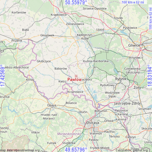
Pawłów GPS coordinates[2]
50° 6' 39.6" North, 18° 7' 43.716" East
| Map corner | latitude | longitude |
|---|---|---|
| Upper-left | 50.55979°, | 17.42569° |
| Center: | 50.111°, | 18.12881° |
| Lower-right: | 49.65796°, | 18.83194° |
| Map W x H: | 100.3×100.3 km | = 62.3×62.3mi |
| max Lat: | 54.83135° ⇑77.5% North |
| Pawłów: | 50.111° |
| min Lat: | ⇓22.5% South 49.21328° |
| min Long | Pawłów | max Long |
| 14.20249° | 18.12881° | 24.03723° |
| W 26.3%⇐ | ⇒73.7% E |
Elevation
Elevation of Pawłów is 229 m = 751 ft, and this is 37.6 m = 123 ft above average elevation for this country.
| Max E: |
974 m = 3196 ft | 30.2% |
| Pawłów | 229 m 751 ft | |
| Avg. | 191.4 m = 628 ft | |
Min E: |
-3 m = -10 ft | 69.8% |
See also: Poland elevation on elevation.city.
Geographical zone
Pawłów is located in North temperate zone (between Tropic of Cancer and the Arctic Circle). Distance of this North polar circle is 1829.4 km =1136.7 mi to North.| Distance of | km | miles | from Pawłów |
|---|---|---|---|
| North Pole | 4435.2 | 2755.9 | to North |
| Arctic Circle | 1829.4 | 1136.7 | to North |
| Tropic Cancer | 2965.9 | 1842.9 | to South |
| Equator | 5571.8 | 3462.2 | to South |


Nearby cities:
15 places around Pawłów: (largest is in red/bold)
• Babice
12.5 km =7.8 mi,  73°
73°
• Baborów
11.5 km =7.1 mi,  296°
296°
• Bojanów
9.5 km =5.9 mi,  164°
164°
• Borucin
11.7 km =7.3 mi,  169°
169°
• Brzeźnica
7.8 km =4.8 mi,  58°
58°
• Kietrz
9.5 km =5.9 mi,  249°
249°
• Kobyła
12.7 km =7.9 mi,  99°
99°
• Krzanowice
10.3 km =6.4 mi,  182°
182°
• Maków
3.3 km =2.1 mi,  266°
266°
• Nieboczowy
11.9 km =7.4 mi,  128°
128°
• Pietrowice Wielkie
4 km =2.5 mi,  222°
222°
• Polska Cerekiew
13 km =8.1 mi,  359°
359°
• Racibórz
6.8 km =4.2 mi,  108°
108°
• Raszczyce
12.2 km =7.6 mi,  84°
84°
• Rudnik
4.5 km =2.8 mi, 66°
Sources, notices
• [Note1] Compared only with cities in Poland existing in our database
• [Src1] Map data: © OpenStreetMap contributors (CC-BY-SA)
• [Src2] Other city data from geonames.org with taken over terms of usage.
• [Src3] Geographical zone / Annual Mean Temperature by Robert A. Rohde @ Wikipedia
