Wielkie Walichnowy geodata
Wielkie Walichnowy (Pomerania) is a populated place; located in Poland in Europe/Warsaw (GMT+2) time zone. With population of 554 people, there are 3400 cities with bigger population in this country. Compared to other cities in Poland, 93.3% of cities are located further ↓South; 62.6% of cities are located further →East and 98.3% of cities have higher elevation than Wielkie Walichnowy. Note1


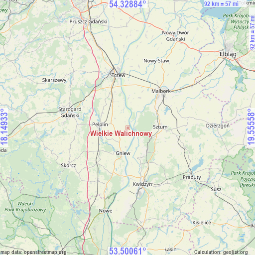
Wielkie Walichnowy GPS coordinates[2]
53° 55' 0.408" North, 18° 51' 8.82" East
| Map corner | latitude | longitude |
|---|---|---|
| Upper-left | 54.32884°, | 18.14933° |
| Center: | 53.91678°, | 18.85245° |
| Lower-right: | 53.50061°, | 19.55558° |
| Map W x H: | 92.1×92.1 km | = 57.2×57.2mi |
| max Lat: | 54.83135° ⇑6.7% North |
| Wielkie Walichnowy: | 53.91678° |
| min Lat: | ⇓93.3% South 49.21328° |
| min Long | Wielkie Walichn | max Long |
| 14.20249° | 18.85245° | 24.03723° |
| W 37.4%⇐ | ⇒62.6% E |
Elevation
Elevation of Wielkie Walichnowy is 9 m = 30 ft, and this is 182.4 m = 598 ft below average elevation for this country.
| Max E: |
974 m = 3196 ft | 98.3% |
| Avg. | 191.4 m = 628 ft | |
| Wielkie Walichnowy | 9 m = 30 ft | |
Min E: |
-3 m = -10 ft | 1.7% |
See also: Poland elevation on elevation.city.
Geographical zone
Wielkie Walichnowy is located in North temperate zone (between Tropic of Cancer and the Arctic Circle). Distance of this North polar circle is 1406.2 km =873.8 mi to North.| Distance of | km | miles | from Wielkie Walichnowy |
|---|---|---|---|
| North Pole | 4012.1 | 2493 | to North |
| Arctic Circle | 1406.2 | 873.8 | to North |
| Tropic Cancer | 3389.1 | 2105.9 | to South |
| Equator | 5995 | 3725.1 | to South |


Nearby cities:
15 places around Wielkie Walichnowy: (largest is in red/bold)
• Bobowo
19.7 km =12.2 mi,  259°
259°
• Czarlin
16.2 km =10.1 mi,  338°
338°
• Gniew
9.2 km =5.7 mi,  192°
192°
• Lisewo Malborskie
20.1 km =12.5 mi,  355°
355°
• Malbork
17.5 km =10.9 mi,  40°
40°
• Mikołajki Pomorskie
21.8 km =13.5 mi,  109°
109°
• Miłoradz
11.6 km =7.2 mi,  21°
21°
• Morzeszczyn
13.6 km =8.5 mi,  231°
231°
• Pelplin
10.2 km =6.3 mi,  277°
277°
• Ryjewo
10.7 km =6.6 mi,  138°
138°
• Stary Targ
20.8 km =12.9 mi,  87°
87°
• Subkowy
11 km =6.8 mi,  330°
330°
• Sztum
11.7 km =7.3 mi, 87°
• Tczew
20.1 km =12.5 mi,  345°
345°
• Zduny
18.2 km =11.3 mi,  305°
305°
Sources, notices
• [Note1] Compared only with cities in Poland existing in our database
• [Src1] Map data: © OpenStreetMap contributors (CC-BY-SA)
• [Src2] Other city data from geonames.org with taken over terms of usage.
• [Src3] Geographical zone / Annual Mean Temperature by Robert A. Rohde @ Wikipedia
