Gniew geodata
Gniew (Pomerania) is a populated place; located in Poland in Europe/Warsaw (GMT+2) time zone. With population of 6,759 people, there are 557 cities with bigger population in this country. Compared to other cities in Poland, 92.6% of cities are located further ↓South; 63% of cities are located further →East and 95.6% of cities have higher elevation than Gniew. Note1


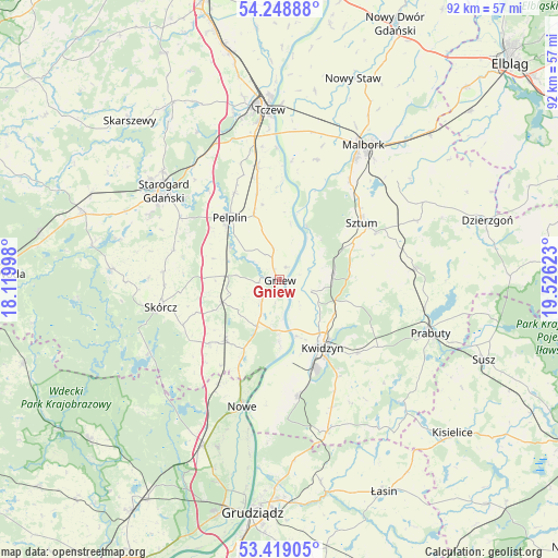
Gniew GPS coordinates[2]
53° 50' 9.672" North, 18° 49' 23.16" East
| Map corner | latitude | longitude |
|---|---|---|
| Upper-left | 54.24888°, | 18.11998° |
| Center: | 53.83602°, | 18.8231° |
| Lower-right: | 53.41905°, | 19.52623° |
| Map W x H: | 92.3×92.3 km | = 57.4×57.4mi |
| max Lat: | 54.83135° ⇑7.4% North |
| Gniew: | 53.83602° |
| min Lat: | ⇓92.6% South 49.21328° |
| min Long | Gniew | max Long |
| 14.20249° | 18.8231° | 24.03723° |
| W 37%⇐ | ⇒63% E |
Elevation
Elevation of Gniew is 35 m = 115 ft, and this is 156.4 m = 513 ft below average elevation for this country.
| Max E: |
974 m = 3196 ft | 95.6% |
| Avg. | 191.4 m = 628 ft | |
| Gniew | 35 m = 115 ft | |
Min E: |
-3 m = -10 ft | 4.4% |
See also: Poland elevation on elevation.city.
Geographical zone
Gniew is located in North temperate zone (between Tropic of Cancer and the Arctic Circle). Distance of this North polar circle is 1415.2 km =879.4 mi to North.| Distance of | km | miles | from Gniew |
|---|---|---|---|
| North Pole | 4021.1 | 2498.6 | to North |
| Arctic Circle | 1415.2 | 879.4 | to North |
| Tropic Cancer | 3380.1 | 2100.3 | to South |
| Equator | 5986 | 3719.5 | to South |


Nearby cities:
15 places around Gniew: (largest is in red/bold)
• Bobowo
18.3 km =11.4 mi,  286°
286°
• Kopytkowo
15.8 km =9.8 mi,  226°
226°
• Kwidzyn
14.2 km =8.8 mi,  150°
150°
• Mikołajki Pomorskie
22.5 km =14 mi,  85°
85°
• Miłoradz
20.7 km =12.9 mi,  17°
17°
• Morzeszczyn
8.7 km =5.4 mi,  272°
272°
• Nowe
21.7 km =13.5 mi,  196°
196°
• Pelplin
13.1 km =8.1 mi,  321°
321°
• Ryjewo
9.1 km =5.7 mi,  83°
83°
• Sadlinki
19.2 km =11.9 mi,  171°
171°
• Skórcz
20.1 km =12.5 mi,  256°
256°
• Smętowo Graniczne
13.4 km =8.3 mi,  222°
222°
• Subkowy
18.8 km =11.7 mi,  349°
349°
• Sztum
16.6 km =10.3 mi,  55°
55°
• Wielkie Walichnowy
9.2 km =5.7 mi,  12°
12°
Sources, notices
• [Note1] Compared only with cities in Poland existing in our database
• [Src1] Map data: © OpenStreetMap contributors (CC-BY-SA)
• [Src2] Other city data from geonames.org with taken over terms of usage.
• [Src3] Geographical zone / Annual Mean Temperature by Robert A. Rohde @ Wikipedia
