Subkowy geodata
Subkowy (Pomerania) is a populated place; located in Poland in Europe/Warsaw (GMT+2) time zone. With population of 1,941 people, there are 1524 cities with bigger population in this country. Compared to other cities in Poland, 94.2% of cities are located further ↓South; 63.9% of cities are located further →East and 96% of cities have higher elevation than Subkowy. Note1


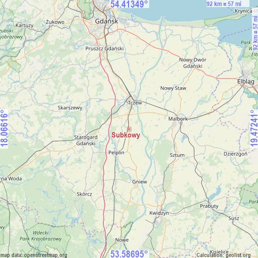
Subkowy GPS coordinates[2]
54° 0' 8.172" North, 18° 46' 9.408" East
| Map corner | latitude | longitude |
|---|---|---|
| Upper-left | 54.41349°, | 18.06616° |
| Center: | 54.00227°, | 18.76928° |
| Lower-right: | 53.58695°, | 19.47241° |
| Map W x H: | 91.9×91.9 km | = 57.1×57.1mi |
| max Lat: | 54.83135° ⇑5.8% North |
| Subkowy: | 54.00227° |
| min Lat: | ⇓94.2% South 49.21328° |
| min Long | Subkowy | max Long |
| 14.20249° | 18.76928° | 24.03723° |
| W 36.1%⇐ | ⇒63.9% E |
Elevation
Elevation of Subkowy is 32 m = 105 ft, and this is 159.4 m = 523 ft below average elevation for this country.
| Max E: |
974 m = 3196 ft | 96% |
| Avg. | 191.4 m = 628 ft | |
| Subkowy | 32 m = 105 ft | |
Min E: |
-3 m = -10 ft | 4% |
See also: Poland elevation on elevation.city.
Geographical zone
Subkowy is located in North temperate zone (between Tropic of Cancer and the Arctic Circle). Distance of this North polar circle is 1396.7 km =867.9 mi to North.| Distance of | km | miles | from Subkowy |
|---|---|---|---|
| North Pole | 4002.6 | 2487.1 | to North |
| Arctic Circle | 1396.7 | 867.9 | to North |
| Tropic Cancer | 3398.6 | 2111.8 | to South |
| Equator | 6004.5 | 3731 | to South |


Nearby cities:
15 places around Subkowy: (largest is in red/bold)
• Bobowo
19.2 km =11.9 mi,  226°
226°
• Czarlin
5.6 km =3.5 mi,  354°
354°
• Gniew
18.8 km =11.7 mi,  169°
169°
• Lichnowy
15.7 km =9.8 mi,  36°
36°
• Lisewo Malborskie
11.2 km =7 mi,  20°
20°
• Malbork
17.2 km =10.7 mi,  77°
77°
• Miłoradz
9.8 km =6.1 mi, 82°
• Morzeszczyn
18.8 km =11.7 mi,  195°
195°
• Pelplin
9.5 km =5.9 mi,  209°
209°
• Pszczółki
19.6 km =12.2 mi, 346°
• Starogard Gdański
16.4 km =10.2 mi,  254°
254°
• Sztum
19.4 km =12.1 mi,  117°
117°
• Tczew
10 km =6.2 mi,  3°
3°
• Wielkie Walichnowy
11 km =6.8 mi,  150°
150°
• Zduny
9.4 km =5.8 mi,  276°
276°
Sources, notices
• [Note1] Compared only with cities in Poland existing in our database
• [Src1] Map data: © OpenStreetMap contributors (CC-BY-SA)
• [Src2] Other city data from geonames.org with taken over terms of usage.
• [Src3] Geographical zone / Annual Mean Temperature by Robert A. Rohde @ Wikipedia
