Kórnica geodata
Kórnica (Opole Voivodeship) is a populated place; located in Poland in Europe/Warsaw (GMT+2) time zone. With population of 770 people, there are 2920 cities with bigger population in this country. Compared to other cities in Poland, 69.3% of cities are located further ↑North; 76.2% of cities are located further →East and 55.2% of cities have lower elevation than Kórnica. Note1
Administrative division(s):
- Level 1: Opole Voivodeship
- Level 2: Powiat krapkowicki
- Level 3: Krapkowice


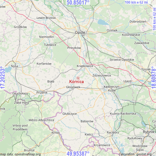
Kórnica GPS coordinates[2]
50° 24' 14.904" North, 17° 54' 20.34" East
| Map corner | latitude | longitude |
|---|---|---|
| Upper-left | 50.85017°, | 17.20253° |
| Center: | 50.40414°, | 17.90565° |
| Lower-right: | 49.95387°, | 18.60878° |
| Map W x H: | 99.7×99.7 km | = 62×62mi |
| max Lat: | 54.83135° ⇑69.3% North |
| Kórnica: | 50.40414° |
| min Lat: | ⇓30.7% South 49.21328° |
| min Long | Kórnica | max Long |
| 14.20249° | 17.90565° | 24.03723° |
| W 23.8%⇐ | ⇒76.2% E |
Elevation
Elevation of Kórnica is 186 m = 610 ft, and this is 5.4 m = 18 ft below average elevation for this country.
| Max E: |
974 m = 3196 ft | 44.8% |
| Avg. | 191.4 m = 628 ft | |
| Kórnica | 186 m = 610 ft | |
Min E: |
-3 m = -10 ft | 55.2% |
See also: Poland elevation on elevation.city.
Geographical zone
Kórnica is located in North temperate zone (between Tropic of Cancer and the Arctic Circle). Distance of this North polar circle is 1796.8 km =1116.5 mi to North.| Distance of | km | miles | from Kórnica |
|---|---|---|---|
| North Pole | 4402.6 | 2735.6 | to North |
| Arctic Circle | 1796.8 | 1116.5 | to North |
| Tropic Cancer | 2998.5 | 1863.2 | to South |
| Equator | 5604.4 | 3482.4 | to South |


Nearby cities:
15 places around Kórnica: (largest is in red/bold)
• Dobieszowice
9.7 km =6 mi,  118°
118°
• Dobra
5.3 km =3.3 mi,  1°
1°
• Gogolin
12.7 km =7.9 mi,  39°
39°
• Głogówek
6.4 km =4 mi,  207°
207°
• Komorno
13.1 km =8.1 mi,  113°
113°
• Krapkowice
9 km =5.6 mi,  28°
28°
• Kujawy
8.2 km =5.1 mi,  301°
301°
• Poborszów
13 km =8.1 mi,  104°
104°
• Pokrzywnica
13.6 km =8.5 mi,  125°
125°
• Racławice Śląskie
13.8 km =8.6 mi,  222°
222°
• Rozkochów
4.5 km =2.8 mi,  146°
146°
• Rozwadza
14.2 km =8.8 mi,  76°
76°
• Strzeleczki
7.3 km =4.5 mi,  331°
331°
• Twardawa
9.1 km =5.7 mi,  138°
138°
• Walce
7.8 km =4.8 mi, 116°
Sources, notices
• [Note1] Compared only with cities in Poland existing in our database
• [Src1] Map data: © OpenStreetMap contributors (CC-BY-SA)
• [Src2] Other city data from geonames.org with taken over terms of usage.
• [Src3] Geographical zone / Annual Mean Temperature by Robert A. Rohde @ Wikipedia
