Świebodzin geodata
Świebodzin (Lubusz) is a seat of a second-order administrative division; located in Poland in Europe/Warsaw (GMT+2) time zone. With population of 21,757 people, there are 226 cities with bigger population in this country. Compared to other cities in Poland, 71.2% of cities are located further ↓South; 95.2% of cities are located further →East and 88.1% of cities have higher elevation than Świebodzin. Note1


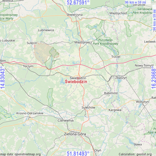
Świebodzin GPS coordinates[2]
52° 14' 51.036" North, 15° 32' 0.78" East
| Map corner | latitude | longitude |
|---|---|---|
| Upper-left | 52.67591°, | 14.83043° |
| Center: | 52.24751°, | 15.53355° |
| Lower-right: | 51.81493°, | 16.23668° |
| Map W x H: | 95.7×95.7 km | = 59.5×59.5mi |
| max Lat: | 54.83135° ⇑28.8% North |
| Świebodzin: | 52.24751° |
| min Lat: | ⇓71.2% South 49.21328° |
| min Long | Świebodzin | max Long |
| 14.20249° | 15.53355° | 24.03723° |
| W 4.8%⇐ | ⇒95.2% E |
Elevation
Elevation of Świebodzin is 81 m = 266 ft, and this is 110.4 m = 362 ft below average elevation for this country.
| Max E: |
974 m = 3196 ft | 88.1% |
| Avg. | 191.4 m = 628 ft | |
| Świebodzin | 81 m = 266 ft | |
Min E: |
-3 m = -10 ft | 11.9% |
See also: Poland elevation on elevation.city.
Geographical zone
Świebodzin is located in North temperate zone (between Tropic of Cancer and the Arctic Circle). Distance of this North polar circle is 1591.8 km =989.1 mi to North.| Distance of | km | miles | from Świebodzin |
|---|---|---|---|
| North Pole | 4197.7 | 2608.3 | to North |
| Arctic Circle | 1591.8 | 989.1 | to North |
| Tropic Cancer | 3203.5 | 1990.6 | to South |
| Equator | 5809.4 | 3609.8 | to South |


Nearby cities:
15 places around Świebodzin: (largest is in red/bold)
• Babimost
22 km =13.7 mi,  114°
114°
• Brody
21.8 km =13.5 mi,  198°
198°
• Brójce
12.3 km =7.6 mi,  50°
50°
• Cigacice
24.1 km =15 mi,  166°
166°
• Kije
16.6 km =10.3 mi,  178°
178°
• Lubrza
8.8 km =5.5 mi,  315°
315°
• Międzylesie
15.4 km =9.6 mi,  221°
221°
• Międzyrzecz
22.1 km =13.7 mi,  7°
7°
• Sieniawa
16.7 km =10.4 mi, 320°
• Skąpe
11.7 km =7.3 mi,  205°
205°
• Sulechów
19.3 km =12 mi,  161°
161°
• Szczaniec
10.4 km =6.5 mi,  76°
76°
• Wilkowo
4.6 km =2.9 mi,  279°
279°
• Zbąszynek
19.3 km =12 mi,  91°
91°
• Łagów
18.7 km =11.6 mi,  301°
301°
Sources, notices
• [Note1] Compared only with cities in Poland existing in our database
• [Src1] Map data: © OpenStreetMap contributors (CC-BY-SA)
• [Src2] Other city data from geonames.org with taken over terms of usage.
• [Src3] Geographical zone / Annual Mean Temperature by Robert A. Rohde @ Wikipedia
