Siedlec geodata
Siedlec (Greater Poland) is a seat of a third-order administrative division; located in Poland in Europe/Warsaw (GMT+2) time zone. With population of 1,200 people, there are 2164 cities with bigger population in this country. Compared to other cities in Poland, 68.5% of cities are located further ↓South; 92.5% of cities are located further →East and 92.7% of cities have higher elevation than Siedlec. Note1


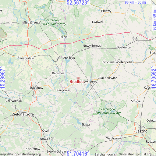
Siedlec GPS coordinates[2]
52° 8' 16.116" North, 16° 0' 10.044" East
| Map corner | latitude | longitude |
|---|---|---|
| Upper-left | 52.56728°, | 15.29967° |
| Center: | 52.13781°, | 16.00279° |
| Lower-right: | 51.70416°, | 16.70592° |
| Map W x H: | 96×96 km | = 59.7×59.7mi |
| max Lat: | 54.83135° ⇑31.5% North |
| Siedlec: | 52.13781° |
| min Lat: | ⇓68.5% South 49.21328° |
| min Long | Siedlec | max Long |
| 14.20249° | 16.00279° | 24.03723° |
| W 7.5%⇐ | ⇒92.5% E |
Elevation
Elevation of Siedlec is 61 m = 200 ft, and this is 130.4 m = 428 ft below average elevation for this country.
| Max E: |
974 m = 3196 ft | 92.7% |
| Avg. | 191.4 m = 628 ft | |
| Siedlec | 61 m = 200 ft | |
Min E: |
-3 m = -10 ft | 7.3% |
See also: Poland elevation on elevation.city.
Geographical zone
Siedlec is located in North temperate zone (between Tropic of Cancer and the Arctic Circle). Distance of this North polar circle is 1604 km =996.7 mi to North.| Distance of | km | miles | from Siedlec |
|---|---|---|---|
| North Pole | 4209.9 | 2615.9 | to North |
| Arctic Circle | 1604 | 996.7 | to North |
| Tropic Cancer | 3191.3 | 1983 | to South |
| Equator | 5797.2 | 3602.2 | to South |


Nearby cities:
15 places around Siedlec: (largest is in red/bold)
• Babimost
12.3 km =7.6 mi,  284°
284°
• Bojadła
24.4 km =15.2 mi,  212°
212°
• Jabłonna
15.9 km =9.9 mi,  61°
61°
• Kargowa
12.2 km =7.6 mi,  232°
232°
• Klenica
22 km =13.7 mi,  222°
222°
• Kolsko
19.8 km =12.3 mi,  188°
188°
• Konotop
23.9 km =14.9 mi,  196°
196°
• Nowy Tomyśl
21.9 km =13.6 mi,  22°
22°
• Rakoniewice
18.5 km =11.5 mi,  89°
89°
• Swarzynice
22.9 km =14.2 mi, 228°
• Trzebiechów
22.4 km =13.9 mi, 234°
• Wielichowo
23.9 km =14.9 mi,  95°
95°
• Wolsztyn
8.2 km =5.1 mi,  107°
107°
• Zbąszynek
17.3 km =10.7 mi,  312°
312°
• Zbąszyń
13.6 km =8.5 mi,  337°
337°
Sources, notices
• [Note1] Compared only with cities in Poland existing in our database
• [Src1] Map data: © OpenStreetMap contributors (CC-BY-SA)
• [Src2] Other city data from geonames.org with taken over terms of usage.
• [Src3] Geographical zone / Annual Mean Temperature by Robert A. Rohde @ Wikipedia
