Wolsztyn geodata
Wolsztyn (Greater Poland) is a seat of a second-order administrative division; located in Poland in Europe/Warsaw (GMT+2) time zone. With population of 13,689 people, there are 361 cities with bigger population in this country. Compared to other cities in Poland, 68.2% of cities are located further ↓South; 91.8% of cities are located further →East and 92.4% of cities have higher elevation than Wolsztyn. Note1


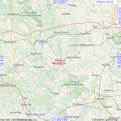
Wolsztyn GPS coordinates[2]
52° 6' 55.872" North, 16° 7' 1.632" East
| Map corner | latitude | longitude |
|---|---|---|
| Upper-left | 52.5452°, | 15.414° |
| Center: | 52.11552°, | 16.11712° |
| Lower-right: | 51.68166°, | 16.82025° |
| Map W x H: | 96×96 km | = 59.7×59.7mi |
| max Lat: | 54.83135° ⇑31.8% North |
| Wolsztyn: | 52.11552° |
| min Lat: | ⇓68.2% South 49.21328° |
| min Long | Wolsztyn | max Long |
| 14.20249° | 16.11712° | 24.03723° |
| W 8.2%⇐ | ⇒91.8% E |
Elevation
Elevation of Wolsztyn is 63 m = 207 ft, and this is 128.4 m = 421 ft below average elevation for this country.
| Max E: |
974 m = 3196 ft | 92.4% |
| Avg. | 191.4 m = 628 ft | |
| Wolsztyn | 63 m = 207 ft | |
Min E: |
-3 m = -10 ft | 7.6% |
See also: Poland elevation on elevation.city.
Geographical zone
Wolsztyn is located in North temperate zone (between Tropic of Cancer and the Arctic Circle). Distance of this North polar circle is 1606.5 km =998.2 mi to North.| Distance of | km | miles | from Wolsztyn |
|---|---|---|---|
| North Pole | 4212.4 | 2617.5 | to North |
| Arctic Circle | 1606.5 | 998.2 | to North |
| Tropic Cancer | 3188.8 | 1981.4 | to South |
| Equator | 5794.7 | 3600.7 | to South |


Nearby cities:
15 places around Wolsztyn: (largest is in red/bold)
• Babimost
20.5 km =12.7 mi,  285°
285°
• Brenno
22.5 km =14 mi,  162°
162°
• Grodzisk Wielkopolski
21 km =13 mi,  53°
53°
• Jabłonna
11.8 km =7.3 mi,  31°
31°
• Kamieniec
24.2 km =15 mi,  76°
76°
• Kargowa
18.1 km =11.2 mi,  254°
254°
• Kolsko
20.2 km =12.6 mi,  212°
212°
• Nowy Tomyśl
22.7 km =14.1 mi,  1°
1°
• Przemęt
17.3 km =10.7 mi,  133°
133°
• Rakoniewice
11 km =6.8 mi, 76°
• Siedlec
8.2 km =5.1 mi, 287°
• Wielichowo
16 km =9.9 mi,  89°
89°
• Wijewo
22.6 km =14 mi,  168°
168°
• Zbąszynek
24.9 km =15.5 mi,  304°
304°
• Zbąszyń
19.9 km =12.4 mi,  319°
319°
Sources, notices
• [Note1] Compared only with cities in Poland existing in our database
• [Src1] Map data: © OpenStreetMap contributors (CC-BY-SA)
• [Src2] Other city data from geonames.org with taken over terms of usage.
• [Src3] Geographical zone / Annual Mean Temperature by Robert A. Rohde @ Wikipedia
