Boża Wola geodata
Boża Wola (Mazovia) is a populated place; located in Poland in Europe/Warsaw (GMT+2) time zone. With population of 700 people, there are 3061 cities with bigger population in this country. Compared to other cities in Poland, 69.8% of cities are located further ↓South; 65.3% of cities are located further ←West and 84.6% of cities have higher elevation than Boża Wola. Note1


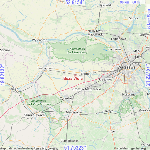
Boża Wola GPS coordinates[2]
52° 11' 11.04" North, 20° 31' 27.984" East
| Map corner | latitude | longitude |
|---|---|---|
| Upper-left | 52.6154°, | 19.82132° |
| Center: | 52.1864°, | 20.52444° |
| Lower-right: | 51.75323°, | 21.22757° |
| Map W x H: | 95.9×95.9 km | = 59.6×59.6mi |
| max Lat: | 54.83135° ⇑30.2% North |
| Boża Wola: | 52.1864° |
| min Lat: | ⇓69.8% South 49.21328° |
| min Long | Boża Wola | max Long |
| 14.20249° | 20.52444° | 24.03723° |
| W 65.3%⇐ | ⇒34.7% E |
Elevation
Elevation of Boża Wola is 90 m = 295 ft, and this is 101.4 m = 333 ft below average elevation for this country.
| Max E: |
974 m = 3196 ft | 84.6% |
| Avg. | 191.4 m = 628 ft | |
| Boża Wola | 90 m = 295 ft | |
Min E: |
-3 m = -10 ft | 15.4% |
See also: Poland elevation on elevation.city.
Geographical zone
Boża Wola is located in North temperate zone (between Tropic of Cancer and the Arctic Circle). Distance of this North polar circle is 1598.6 km =993.3 mi to North.| Distance of | km | miles | from Boża Wola |
|---|---|---|---|
| North Pole | 4204.5 | 2612.6 | to North |
| Arctic Circle | 1598.6 | 993.3 | to North |
| Tropic Cancer | 3196.7 | 1986.3 | to South |
| Equator | 5802.6 | 3605.6 | to South |


Nearby cities:
15 places around Boża Wola: (largest is in red/bold)
• Bieniewice
2.7 km =1.7 mi,  98°
98°
• Brwinów
14 km =8.7 mi,  110°
110°
• Błonie
6.5 km =4 mi,  77°
77°
• Grodzisk Mazowiecki
11.8 km =7.3 mi,  140°
140°
• Guzów
15 km =9.3 mi,  238°
238°
• Jaktorów
12.1 km =7.5 mi,  173°
173°
• Józefów
11.7 km =7.3 mi,  85°
85°
• Kampinos
10 km =6.2 mi,  335°
335°
• Leszno
9.2 km =5.7 mi,  29°
29°
• Milanówek
12.5 km =7.8 mi,  126°
126°
• Owczarnia
14.9 km =9.3 mi,  124°
124°
• Paprotnia
7.2 km =4.5 mi,  286°
286°
• Teresin
7.5 km =4.7 mi,  280°
280°
• Wiskitki
14.4 km =8.9 mi,  220°
220°
• Zaborów
13.4 km =8.3 mi,  50°
50°
Sources, notices
• [Note1] Compared only with cities in Poland existing in our database
• [Src1] Map data: © OpenStreetMap contributors (CC-BY-SA)
• [Src2] Other city data from geonames.org with taken over terms of usage.
• [Src3] Geographical zone / Annual Mean Temperature by Robert A. Rohde @ Wikipedia
