Grodzisk Mazowiecki geodata
Grodzisk Mazowiecki (Mazovia) is a seat of a second-order administrative division; located in Poland in Europe/Warsaw (GMT+2) time zone. With population of 26,684 people, there are 182 cities with bigger population in this country. Compared to other cities in Poland, 67.9% of cities are located further ↓South; 66.7% of cities are located further ←West and 78.4% of cities have higher elevation than Grodzisk Mazowiecki. Note1


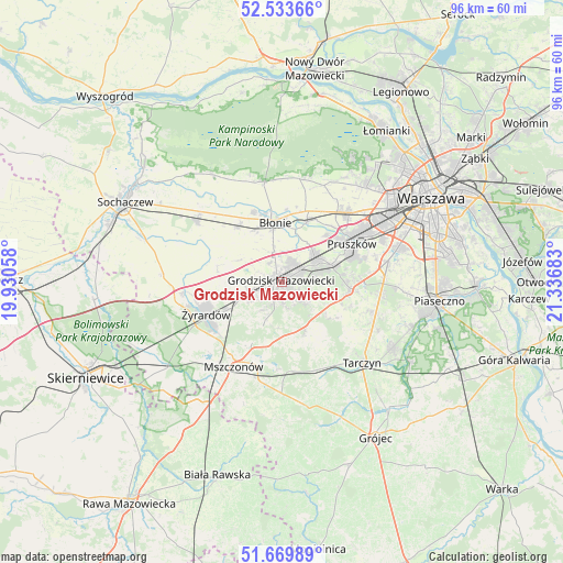
Grodzisk Mazowiecki GPS coordinates[2]
52° 6' 13.932" North, 20° 38' 1.32" East
| Map corner | latitude | longitude |
|---|---|---|
| Upper-left | 52.53366°, | 19.93058° |
| Center: | 52.10387°, | 20.6337° |
| Lower-right: | 51.66989°, | 21.33683° |
| Map W x H: | 96×96 km | = 59.7×59.7mi |
| max Lat: | 54.83135° ⇑32.1% North |
| Grodzisk Mazowiecki: | 52.10387° |
| min Lat: | ⇓67.9% South 49.21328° |
| min Long | Grodzisk Mazowi | max Long |
| 14.20249° | 20.6337° | 24.03723° |
| W 66.7%⇐ | ⇒33.3% E |
Elevation
Elevation of Grodzisk Mazowiecki is 103 m = 338 ft, and this is 88.4 m = 290 ft below average elevation for this country.
| Max E: |
974 m = 3196 ft | 78.4% |
| Avg. | 191.4 m = 628 ft | |
| Grodzisk Mazowiecki | 103 m = 338 ft | |
Min E: |
-3 m = -10 ft | 21.6% |
See also: Poland elevation on elevation.city.
Geographical zone
Grodzisk Mazowiecki is located in North temperate zone (between Tropic of Cancer and the Arctic Circle). Distance of this North polar circle is 1607.8 km =999 mi to North.| Distance of | km | miles | from Grodzisk Mazowiecki |
|---|---|---|---|
| North Pole | 4213.7 | 2618.3 | to North |
| Arctic Circle | 1607.8 | 999 | to North |
| Tropic Cancer | 3187.5 | 1980.6 | to South |
| Equator | 5793.4 | 3599.9 | to South |


Nearby cities:
15 places around Grodzisk Mazowiecki: (largest is in red/bold)
• Bieniewice
10 km =6.2 mi,  331°
331°
• Boża Wola
11.8 km =7.3 mi,  320°
320°
• Brwinów
7.1 km =4.4 mi,  52°
52°
• Błonie
10.6 km =6.6 mi,  353°
353°
• Granica
12 km =7.5 mi,  74°
74°
• Jaktorów
6.7 km =4.2 mi,  244°
244°
• Józefów
10.9 km =6.8 mi,  22°
22°
• Kanie
10 km =6.2 mi, 67°
• Książenice
5.2 km =3.2 mi,  124°
124°
• Milanówek
3.1 km =1.9 mi,  57°
57°
• Nadarzyn
11.9 km =7.4 mi,  95°
95°
• Otrębusy
9.1 km =5.7 mi, 72°
• Owczarnia
4.9 km =3 mi,  80°
80°
• Podkowa Leśna
6.7 km =4.2 mi, 72°
• Żabia Wola
8.9 km =5.5 mi,  153°
153°
Sources, notices
• [Note1] Compared only with cities in Poland existing in our database
• [Src1] Map data: © OpenStreetMap contributors (CC-BY-SA)
• [Src2] Other city data from geonames.org with taken over terms of usage.
• [Src3] Geographical zone / Annual Mean Temperature by Robert A. Rohde @ Wikipedia
