Wiskitki geodata
Wiskitki (Mazovia) is a populated place; located in Poland in Europe/Warsaw (GMT+2) time zone. With population of 1,420 people, there are 1935 cities with bigger population in this country. Compared to other cities in Poland, 67.5% of cities are located further ↓South; 63.5% of cities are located further ←West and 79.8% of cities have higher elevation than Wiskitki. Note1


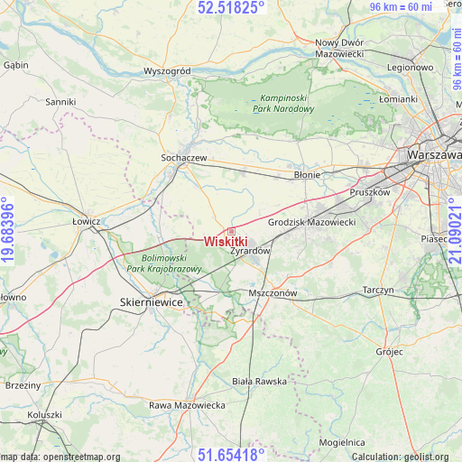
Wiskitki GPS coordinates[2]
52° 5' 17.916" North, 20° 23' 13.488" East
| Map corner | latitude | longitude |
|---|---|---|
| Upper-left | 52.51825°, | 19.68396° |
| Center: | 52.08831°, | 20.38708° |
| Lower-right: | 51.65418°, | 21.09021° |
| Map W x H: | 96.1×96.1 km | = 59.7×59.7mi |
| max Lat: | 54.83135° ⇑32.5% North |
| Wiskitki: | 52.08831° |
| min Lat: | ⇓67.5% South 49.21328° |
| min Long | Wiskitki | max Long |
| 14.20249° | 20.38708° | 24.03723° |
| W 63.5%⇐ | ⇒36.5% E |
Elevation
Elevation of Wiskitki is 100 m = 328 ft, and this is 91.4 m = 300 ft below average elevation for this country.
| Max E: |
974 m = 3196 ft | 79.8% |
| Avg. | 191.4 m = 628 ft | |
| Wiskitki | 100 m = 328 ft | |
Min E: |
-3 m = -10 ft | 20.2% |
See also: Poland elevation on elevation.city.
Geographical zone
Wiskitki is located in North temperate zone (between Tropic of Cancer and the Arctic Circle). Distance of this North polar circle is 1609.5 km =1000.1 mi to North.| Distance of | km | miles | from Wiskitki |
|---|---|---|---|
| North Pole | 4215.4 | 2619.3 | to North |
| Arctic Circle | 1609.5 | 1000.1 | to North |
| Tropic Cancer | 3185.8 | 1979.6 | to South |
| Equator | 5791.7 | 3598.8 | to South |


Nearby cities:
15 places around Wiskitki: (largest is in red/bold)
• Bieniewice
15.9 km =9.9 mi,  48°
48°
• Bolimów
15.3 km =9.5 mi,  265°
265°
• Boża Wola
14.4 km =8.9 mi,  40°
40°
• Franciszków
8.4 km =5.2 mi,  207°
207°
• Guzów
4.6 km =2.9 mi,  312°
312°
• Jaktorów
10.9 km =6.8 mi,  95°
95°
• Jesionka
7.5 km =4.7 mi,  197°
197°
• Miedniewice
5.8 km =3.6 mi,  264°
264°
• Mrozy
7.7 km =4.8 mi,  190°
190°
• Mszczonów
15.6 km =9.7 mi,  144°
144°
• Paprotnia
13.2 km =8.2 mi,  10°
10°
• Puszcza Mariańska
12.4 km =7.7 mi, 191°
• Radziejowice
14.1 km =8.8 mi,  128°
128°
• Teresin
12.5 km =7.8 mi, 9°
• Żyrardów
6 km =3.7 mi, 137°
Sources, notices
• [Note1] Compared only with cities in Poland existing in our database
• [Src1] Map data: © OpenStreetMap contributors (CC-BY-SA)
• [Src2] Other city data from geonames.org with taken over terms of usage.
• [Src3] Geographical zone / Annual Mean Temperature by Robert A. Rohde @ Wikipedia
