Jaktorów geodata
Jaktorów (Mazovia) is a populated place; located in Poland in Europe/Warsaw (GMT+2) time zone. With population of 910 people, there are 2657 cities with bigger population in this country. Compared to other cities in Poland, 67.3% of cities are located further ↓South; 65.6% of cities are located further ←West and 75% of cities have higher elevation than Jaktorów. Note1


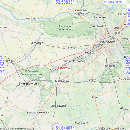
Jaktorów GPS coordinates[2]
52° 4' 41.844" North, 20° 32' 43.656" East
| Map corner | latitude | longitude |
|---|---|---|
| Upper-left | 52.50833°, | 19.84234° |
| Center: | 52.07829°, | 20.54546° |
| Lower-right: | 51.64407°, | 21.24859° |
| Map W x H: | 96.1×96.1 km | = 59.7×59.7mi |
| max Lat: | 54.83135° ⇑32.7% North |
| Jaktorów: | 52.07829° |
| min Lat: | ⇓67.3% South 49.21328° |
| min Long | Jaktorów | max Long |
| 14.20249° | 20.54546° | 24.03723° |
| W 65.6%⇐ | ⇒34.4% E |
Elevation
Elevation of Jaktorów is 111 m = 364 ft, and this is 80.4 m = 264 ft below average elevation for this country.
| Max E: |
974 m = 3196 ft | 75% |
| Avg. | 191.4 m = 628 ft | |
| Jaktorów | 111 m = 364 ft | |
Min E: |
-3 m = -10 ft | 25% |
See also: Poland elevation on elevation.city.
Geographical zone
Jaktorów is located in North temperate zone (between Tropic of Cancer and the Arctic Circle). Distance of this North polar circle is 1610.6 km =1000.8 mi to North.| Distance of | km | miles | from Jaktorów |
|---|---|---|---|
| North Pole | 4216.5 | 2620 | to North |
| Arctic Circle | 1610.6 | 1000.8 | to North |
| Tropic Cancer | 3184.6 | 1978.8 | to South |
| Equator | 5790.6 | 3598.1 | to South |


Nearby cities:
15 places around Jaktorów: (largest is in red/bold)
• Bieniewice
11.7 km =7.3 mi,  5°
5°
• Boża Wola
12.1 km =7.5 mi,  353°
353°
• Brwinów
13.7 km =8.5 mi,  58°
58°
• Błonie
14.2 km =8.8 mi,  20°
20°
• Grodzisk Mazowiecki
6.7 km =4.2 mi, 64°
• Książenice
10.3 km =6.4 mi,  90°
90°
• Milanówek
9.7 km =6 mi, 62°
• Mrozy
13.8 km =8.6 mi,  241°
241°
• Mszczonów
11.7 km =7.3 mi,  188°
188°
• Owczarnia
11.5 km =7.1 mi,  71°
71°
• Podkowa Leśna
13.3 km =8.3 mi, 68°
• Radziejowice
7.8 km =4.8 mi,  178°
178°
• Wiskitki
10.9 km =6.8 mi,  275°
275°
• Żabia Wola
11.2 km =7 mi,  117°
117°
• Żyrardów
7.5 km =4.7 mi, 244°
Sources, notices
• [Note1] Compared only with cities in Poland existing in our database
• [Src1] Map data: © OpenStreetMap contributors (CC-BY-SA)
• [Src2] Other city data from geonames.org with taken over terms of usage.
• [Src3] Geographical zone / Annual Mean Temperature by Robert A. Rohde @ Wikipedia
