Złota geodata
Złota (Świętokrzyskie) is a seat of a third-order administrative division; located in Poland in Europe/Warsaw (GMT+2) time zone. With population of 1,200 people, there are 2164 cities with bigger population in this country. Compared to other cities in Poland, 69.9% of cities are located further ↑North; 66.3% of cities are located further ←West and 60% of cities have lower elevation than Złota. Note1


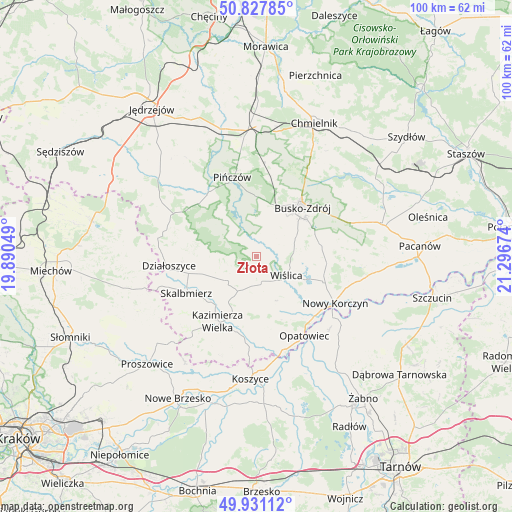
Złota GPS coordinates[2]
50° 22' 53.76" North, 20° 35' 36.996" East
| Map corner | latitude | longitude |
|---|---|---|
| Upper-left | 50.82785°, | 19.89049° |
| Center: | 50.3816°, | 20.59361° |
| Lower-right: | 49.93112°, | 21.29674° |
| Map W x H: | 99.7×99.7 km | = 62×62mi |
| max Lat: | 54.83135° ⇑69.9% North |
| Złota: | 50.3816° |
| min Lat: | ⇓30.1% South 49.21328° |
| min Long | Złota | max Long |
| 14.20249° | 20.59361° | 24.03723° |
| W 66.3%⇐ | ⇒33.7% E |
Elevation
Elevation of Złota is 200 m = 656 ft, and this is 8.6 m = 28 ft above average elevation for this country.
| Max E: |
974 m = 3196 ft | 40% |
| Złota | 200 m 656 ft | |
| Avg. | 191.4 m = 628 ft | |
Min E: |
-3 m = -10 ft | 60% |
See also: Poland elevation on elevation.city.
Geographical zone
Złota is located in North temperate zone (between Tropic of Cancer and the Arctic Circle). Distance of this North polar circle is 1799.3 km =1118 mi to North.| Distance of | km | miles | from Złota |
|---|---|---|---|
| North Pole | 4405.2 | 2737.3 | to North |
| Arctic Circle | 1799.3 | 1118 | to North |
| Tropic Cancer | 2996 | 1861.6 | to South |
| Equator | 5601.9 | 3480.9 | to South |


Nearby cities:
15 places around Złota: (largest is in red/bold)
• Bejsce
15.9 km =9.9 mi,  178°
178°
• Busko-Zdrój
13.3 km =8.3 mi,  41°
41°
• Czarnocin
7.1 km =4.4 mi,  230°
230°
• Działoszyce
17.2 km =10.7 mi,  263°
263°
• Gręboszów
20 km =12.4 mi,  139°
139°
• Kazimierza Wielka
14.7 km =9.1 mi,  208°
208°
• Michałów
15.7 km =9.8 mi,  323°
323°
• Nowy Korczyn
17.6 km =10.9 mi,  120°
120°
• Opatowiec
17.9 km =11.1 mi,  149°
149°
• Pałecznica
23 km =14.3 mi,  243°
243°
• Pińczów
16.2 km =10.1 mi,  342°
342°
• Skalbmierz
15.4 km =9.6 mi, 243°
• Solec-Zdrój
21.1 km =13.1 mi,  94°
94°
• Widuchowa
18.8 km =11.7 mi,  50°
50°
• Wiślica
6.8 km =4.2 mi, 122°
Sources, notices
• [Note1] Compared only with cities in Poland existing in our database
• [Src1] Map data: © OpenStreetMap contributors (CC-BY-SA)
• [Src2] Other city data from geonames.org with taken over terms of usage.
• [Src3] Geographical zone / Annual Mean Temperature by Robert A. Rohde @ Wikipedia
