Busko-Zdrój geodata
Busko-Zdrój (Świętokrzyskie) is a seat of a second-order administrative division; located in Poland in Europe/Warsaw (GMT+2) time zone. With population of 17,095 people, there are 289 cities with bigger population in this country. Compared to other cities in Poland, 67.8% of cities are located further ↑North; 68% of cities are located further ←West and 80% of cities have lower elevation than Busko-Zdrój. Note1


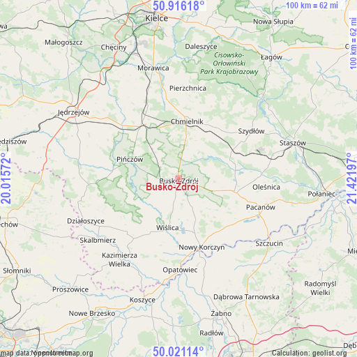
Busko-Zdrój GPS coordinates[2]
50° 28' 14.808" North, 20° 43' 7.824" East
| Map corner | latitude | longitude |
|---|---|---|
| Upper-left | 50.91618°, | 20.01572° |
| Center: | 50.47078°, | 20.71884° |
| Lower-right: | 50.02114°, | 21.42197° |
| Map W x H: | 99.5×99.5 km | = 61.8×61.8mi |
| max Lat: | 54.83135° ⇑67.8% North |
| Busko-Zdrój: | 50.47078° |
| min Lat: | ⇓32.2% South 49.21328° |
| min Long | Busko-Zdrój | max Long |
| 14.20249° | 20.71884° | 24.03723° |
| W 68%⇐ | ⇒32% E |
Elevation
Elevation of Busko-Zdrój is 266 m = 873 ft, and this is 74.6 m = 245 ft above average elevation for this country.
| Max E: |
974 m = 3196 ft | 20% |
| Busko-Zdrój | 266 m 873 ft | |
| Avg. | 191.4 m = 628 ft | |
Min E: |
-3 m = -10 ft | 80% |
See also: Poland elevation on elevation.city.
Geographical zone
Busko-Zdrój is located in North temperate zone (between Tropic of Cancer and the Arctic Circle). Distance of this North polar circle is 1789.3 km =1111.8 mi to North.| Distance of | km | miles | from Busko-Zdrój |
|---|---|---|---|
| North Pole | 4395.2 | 2731 | to North |
| Arctic Circle | 1789.3 | 1111.8 | to North |
| Tropic Cancer | 3005.9 | 1867.8 | to South |
| Equator | 5611.8 | 3487 | to South |


Nearby cities:
15 places around Busko-Zdrój: (largest is in red/bold)
• Chmielnik
16.1 km =10 mi,  8°
8°
• Czarnocin
20.4 km =12.7 mi,  224°
224°
• Gnojno
17.3 km =10.7 mi,  32°
32°
• Imielno
23 km =14.3 mi,  303°
303°
• Kije
18.4 km =11.4 mi,  325°
325°
• Michałów
18.4 km =11.4 mi,  278°
278°
• Nowy Korczyn
19.9 km =12.4 mi,  161°
161°
• Pacanów
24.2 km =15 mi,  108°
108°
• Pińczów
14.7 km =9.1 mi,  292°
292°
• Solec-Zdrój
16.8 km =10.4 mi,  133°
133°
• Stopnica
15.9 km =9.9 mi,  102°
102°
• Tuczępy
20 km =12.4 mi,  75°
75°
• Widuchowa
5.9 km =3.7 mi,  68°
68°
• Wiślica
13.9 km =8.6 mi,  193°
193°
• Złota
13.3 km =8.3 mi, 221°
Sources, notices
• [Note1] Compared only with cities in Poland existing in our database
• [Src1] Map data: © OpenStreetMap contributors (CC-BY-SA)
• [Src2] Other city data from geonames.org with taken over terms of usage.
• [Src3] Geographical zone / Annual Mean Temperature by Robert A. Rohde @ Wikipedia
