Solec-Zdrój geodata
Solec-Zdrój (Świętokrzyskie) is a seat of a third-order administrative division; located in Poland in Europe/Warsaw (GMT+2) time zone. With population of 900 people, there are 2674 cities with bigger population in this country. Compared to other cities in Poland, 70.4% of cities are located further ↑North; 70.6% of cities are located further ←West and 54.6% of cities have lower elevation than Solec-Zdrój. Note1


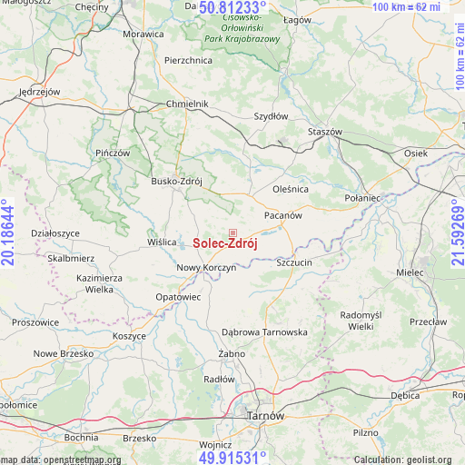
Solec-Zdrój GPS coordinates[2]
50° 21' 57.384" North, 20° 53' 22.416" East
| Map corner | latitude | longitude |
|---|---|---|
| Upper-left | 50.81233°, | 20.18644° |
| Center: | 50.36594°, | 20.88956° |
| Lower-right: | 49.91531°, | 21.59269° |
| Map W x H: | 99.7×99.7 km | = 62×62mi |
| max Lat: | 54.83135° ⇑70.4% North |
| Solec-Zdrój: | 50.36594° |
| min Lat: | ⇓29.6% South 49.21328° |
| min Long | Solec-Zdrój | max Long |
| 14.20249° | 20.88956° | 24.03723° |
| W 70.6%⇐ | ⇒29.4% E |
Elevation
Elevation of Solec-Zdrój is 184 m = 604 ft, and this is 7.4 m = 24 ft below average elevation for this country.
| Max E: |
974 m = 3196 ft | 45.4% |
| Avg. | 191.4 m = 628 ft | |
| Solec-Zdrój | 184 m = 604 ft | |
Min E: |
-3 m = -10 ft | 54.6% |
See also: Poland elevation on elevation.city.
Geographical zone
Solec-Zdrój is located in North temperate zone (between Tropic of Cancer and the Arctic Circle). Distance of this North polar circle is 1801 km =1119.1 mi to North.| Distance of | km | miles | from Solec-Zdrój |
|---|---|---|---|
| North Pole | 4406.9 | 2738.3 | to North |
| Arctic Circle | 1801 | 1119.1 | to North |
| Tropic Cancer | 2994.2 | 1860.5 | to South |
| Equator | 5600.2 | 3479.8 | to South |


Nearby cities:
15 places around Solec-Zdrój: (largest is in red/bold)
• Bolesław
10.3 km =6.4 mi,  175°
175°
• Busko-Zdrój
16.8 km =10.4 mi,  313°
313°
• Gręboszów
15.7 km =9.8 mi,  210°
210°
• Mędrzechów
10.2 km =6.3 mi,  156°
156°
• Nowy Korczyn
9.3 km =5.8 mi,  218°
218°
• Oleśnica
15.8 km =9.8 mi,  51°
51°
• Opatowiec
18 km =11.2 mi, 220°
• Pacanów
11.4 km =7.1 mi,  70°
70°
• Smęgorzów
17.3 km =10.7 mi,  151°
151°
• Stopnica
8.9 km =5.5 mi,  22°
22°
• Szczucin
14.5 km =9 mi,  115°
115°
• Słupia
10.8 km =6.7 mi,  79°
79°
• Tuczępy
18.3 km =11.4 mi, 23°
• Widuchowa
15.3 km =9.5 mi,  334°
334°
• Wiślica
15.4 km =9.6 mi,  262°
262°
Sources, notices
• [Note1] Compared only with cities in Poland existing in our database
• [Src1] Map data: © OpenStreetMap contributors (CC-BY-SA)
• [Src2] Other city data from geonames.org with taken over terms of usage.
• [Src3] Geographical zone / Annual Mean Temperature by Robert A. Rohde @ Wikipedia
