Bejsce geodata
Bejsce (Świętokrzyskie) is a seat of a third-order administrative division; located in Poland in Europe/Warsaw (GMT+2) time zone. With population of 878 people, there are 2716 cities with bigger population in this country. Compared to other cities in Poland, 73.5% of cities are located further ↑North; 66.4% of cities are located further ←West and 54.4% of cities have lower elevation than Bejsce. Note1


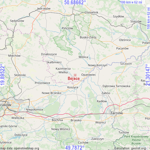
Bejsce GPS coordinates[2]
50° 14' 20.508" North, 20° 35' 54.024" East
| Map corner | latitude | longitude |
|---|---|---|
| Upper-left | 50.68662°, | 19.89522° |
| Center: | 50.23903°, | 20.59834° |
| Lower-right: | 49.7872°, | 21.30147° |
| Map W x H: | 100×100 km | = 62.1×62.1mi |
| max Lat: | 54.83135° ⇑73.5% North |
| Bejsce: | 50.23903° |
| min Lat: | ⇓26.5% South 49.21328° |
| min Long | Bejsce | max Long |
| 14.20249° | 20.59834° | 24.03723° |
| W 66.4%⇐ | ⇒33.6% E |
Elevation
Elevation of Bejsce is 183 m = 600 ft, and this is 8.4 m = 28 ft below average elevation for this country.
| Max E: |
974 m = 3196 ft | 45.6% |
| Avg. | 191.4 m = 628 ft | |
| Bejsce | 183 m = 600 ft | |
Min E: |
-3 m = -10 ft | 54.4% |
See also: Poland elevation on elevation.city.
Geographical zone
Bejsce is located in North temperate zone (between Tropic of Cancer and the Arctic Circle). Distance of this North polar circle is 1815.1 km =1127.9 mi to North.| Distance of | km | miles | from Bejsce |
|---|---|---|---|
| North Pole | 4421 | 2747.1 | to North |
| Arctic Circle | 1815.1 | 1127.9 | to North |
| Tropic Cancer | 2980.1 | 1851.7 | to South |
| Equator | 5586.1 | 3471 | to South |


Nearby cities:
15 places around Bejsce: (largest is in red/bold)
• Czarnocin
12.7 km =7.9 mi,  332°
332°
• Gręboszów
12.7 km =7.9 mi,  86°
86°
• Jadowniki Mokre
12.4 km =7.7 mi,  131°
131°
• Kazimierza Wielka
8 km =5 mi,  291°
291°
• Koszyce
7.8 km =4.8 mi,  190°
190°
• Kościelec
15.3 km =9.5 mi,  253°
253°
• Miechowice Małe
14.5 km =9 mi,  122°
122°
• Miechowice Wielkie
11.7 km =7.3 mi, 117°
• Opatowiec
8.9 km =5.5 mi, 87°
• Szczurowa
13.6 km =8.5 mi,  168°
168°
• Uście Solne
14.6 km =9.1 mi,  204°
204°
• Wietrzychowice
13 km =8.1 mi,  114°
114°
• Wiślica
13.4 km =8.3 mi,  23°
23°
• Zaborów
12.2 km =7.6 mi,  147°
147°
• Złota
15.9 km =9.9 mi,  358°
358°
Sources, notices
• [Note1] Compared only with cities in Poland existing in our database
• [Src1] Map data: © OpenStreetMap contributors (CC-BY-SA)
• [Src2] Other city data from geonames.org with taken over terms of usage.
• [Src3] Geographical zone / Annual Mean Temperature by Robert A. Rohde @ Wikipedia
