Opatowiec geodata
Opatowiec (Świętokrzyskie) is a seat of a third-order administrative division; located in Poland in Europe/Warsaw (GMT+2) time zone. With population of 410 people, there are 3583 cities with bigger population in this country. Compared to other cities in Poland, 73.4% of cities are located further ↑North; 68.1% of cities are located further ←West and 55.6% of cities have lower elevation than Opatowiec. Note1


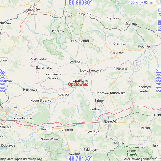
Opatowiec GPS coordinates[2]
50° 14' 35.304" North, 20° 43' 24.528" East
| Map corner | latitude | longitude |
|---|---|---|
| Upper-left | 50.69069°, | 20.02036° |
| Center: | 50.24314°, | 20.72348° |
| Lower-right: | 49.79135°, | 21.42661° |
| Map W x H: | 100×100 km | = 62.1×62.1mi |
| max Lat: | 54.83135° ⇑73.4% North |
| Opatowiec: | 50.24314° |
| min Lat: | ⇓26.6% South 49.21328° |
| min Long | Opatowiec | max Long |
| 14.20249° | 20.72348° | 24.03723° |
| W 68.1%⇐ | ⇒31.9% E |
Elevation
Elevation of Opatowiec is 187 m = 614 ft, and this is 4.4 m = 14 ft below average elevation for this country.
| Max E: |
974 m = 3196 ft | 44.4% |
| Avg. | 191.4 m = 628 ft | |
| Opatowiec | 187 m = 614 ft | |
Min E: |
-3 m = -10 ft | 55.6% |
See also: Poland elevation on elevation.city.
Geographical zone
Opatowiec is located in North temperate zone (between Tropic of Cancer and the Arctic Circle). Distance of this North polar circle is 1814.7 km =1127.6 mi to North.| Distance of | km | miles | from Opatowiec |
|---|---|---|---|
| North Pole | 4420.5 | 2746.8 | to North |
| Arctic Circle | 1814.7 | 1127.6 | to North |
| Tropic Cancer | 2980.6 | 1852.1 | to South |
| Equator | 5586.5 | 3471.3 | to South |


Nearby cities:
15 places around Opatowiec: (largest is in red/bold)
• Bejsce
8.9 km =5.5 mi,  267°
267°
• Bolesław
13 km =8.1 mi,  75°
75°
• Gorzyce
11.8 km =7.3 mi,  124°
124°
• Gręboszów
3.8 km =2.4 mi,  86°
86°
• Jadowniki Mokre
8.6 km =5.3 mi,  177°
177°
• Koszyce
13.1 km =8.1 mi,  231°
231°
• Miechowice Małe
8.9 km =5.5 mi,  158°
158°
• Miechowice Wielkie
6 km =3.7 mi,  165°
165°
• Nieciecza
13.5 km =8.4 mi,  138°
138°
• Nowy Korczyn
8.8 km =5.5 mi,  42°
42°
• Olesno
15.1 km =9.4 mi,  107°
107°
• Przybysławice
10.8 km =6.7 mi,  148°
148°
• Wietrzychowice
6.5 km =4 mi, 153°
• Wiślica
12.3 km =7.6 mi,  343°
343°
• Zaborów
11 km =6.8 mi,  192°
192°
Sources, notices
• [Note1] Compared only with cities in Poland existing in our database
• [Src1] Map data: © OpenStreetMap contributors (CC-BY-SA)
• [Src2] Other city data from geonames.org with taken over terms of usage.
• [Src3] Geographical zone / Annual Mean Temperature by Robert A. Rohde @ Wikipedia
