Wiślica geodata
Wiślica (Świętokrzyskie) is a seat of a third-order administrative division; located in Poland in Europe/Warsaw (GMT+2) time zone. With population of 680 people, there are 3110 cities with bigger population in this country. Compared to other cities in Poland, 70.9% of cities are located further ↑North; 67.1% of cities are located further ←West and 53.8% of cities have lower elevation than Wiślica. Note1


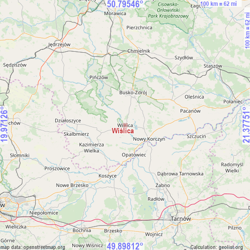
Wiślica GPS coordinates[2]
50° 20' 56.076" North, 20° 40' 27.768" East
| Map corner | latitude | longitude |
|---|---|---|
| Upper-left | 50.79546°, | 19.97126° |
| Center: | 50.34891°, | 20.67438° |
| Lower-right: | 49.89812°, | 21.37751° |
| Map W x H: | 99.8×99.8 km | = 62×62mi |
| max Lat: | 54.83135° ⇑70.9% North |
| Wiślica: | 50.34891° |
| min Lat: | ⇓29.1% South 49.21328° |
| min Long | Wiślica | max Long |
| 14.20249° | 20.67438° | 24.03723° |
| W 67.1%⇐ | ⇒32.9% E |
Elevation
Elevation of Wiślica is 182 m = 597 ft, and this is 9.4 m = 31 ft below average elevation for this country.
| Max E: |
974 m = 3196 ft | 46.2% |
| Avg. | 191.4 m = 628 ft | |
| Wiślica | 182 m = 597 ft | |
Min E: |
-3 m = -10 ft | 53.8% |
See also: Poland elevation on elevation.city.
Geographical zone
Wiślica is located in North temperate zone (between Tropic of Cancer and the Arctic Circle). Distance of this North polar circle is 1802.9 km =1120.3 mi to North.| Distance of | km | miles | from Wiślica |
|---|---|---|---|
| North Pole | 4408.8 | 2739.5 | to North |
| Arctic Circle | 1802.9 | 1120.3 | to North |
| Tropic Cancer | 2992.4 | 1859.4 | to South |
| Equator | 5598.3 | 3478.6 | to South |


Nearby cities:
15 places around Wiślica: (largest is in red/bold)
• Bejsce
13.4 km =8.3 mi,  203°
203°
• Bolesław
18.1 km =11.2 mi,  117°
117°
• Busko-Zdrój
13.9 km =8.6 mi,  13°
13°
• Czarnocin
11.3 km =7 mi,  265°
265°
• Gręboszów
13.6 km =8.5 mi,  147°
147°
• Kazimierza Wielka
15.8 km =9.8 mi,  234°
234°
• Miechowice Wielkie
18.2 km =11.3 mi,  164°
164°
• Mędrzechów
20.8 km =12.9 mi,  110°
110°
• Nowy Korczyn
10.8 km =6.7 mi, 119°
• Opatowiec
12.3 km =7.6 mi, 163°
• Skalbmierz
19.8 km =12.3 mi,  260°
260°
• Solec-Zdrój
15.4 km =9.6 mi,  82°
82°
• Widuchowa
18 km =11.2 mi,  28°
28°
• Wietrzychowice
18.7 km =11.6 mi, 159°
• Złota
6.8 km =4.2 mi,  302°
302°
Sources, notices
• [Note1] Compared only with cities in Poland existing in our database
• [Src1] Map data: © OpenStreetMap contributors (CC-BY-SA)
• [Src2] Other city data from geonames.org with taken over terms of usage.
• [Src3] Geographical zone / Annual Mean Temperature by Robert A. Rohde @ Wikipedia
