Nowy Korczyn geodata
Nowy Korczyn (Świętokrzyskie) is a seat of a third-order administrative division; located in Poland in Europe/Warsaw (GMT+2) time zone. With population of 1,032 people, there are 2419 cities with bigger population in this country. Compared to other cities in Poland, 72% of cities are located further ↑North; 69.2% of cities are located further ←West and 50.2% of cities have lower elevation than Nowy Korczyn. Note1


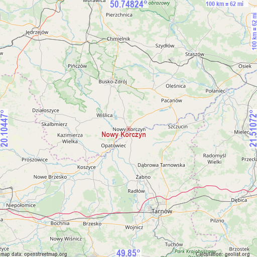
Nowy Korczyn GPS coordinates[2]
50° 18' 4.464" North, 20° 48' 27.324" East
| Map corner | latitude | longitude |
|---|---|---|
| Upper-left | 50.74824°, | 20.10447° |
| Center: | 50.30124°, | 20.80759° |
| Lower-right: | 49.85°, | 21.51072° |
| Map W x H: | 99.9×99.9 km | = 62.1×62.1mi |
| max Lat: | 54.83135° ⇑72% North |
| Nowy Korczyn: | 50.30124° |
| min Lat: | ⇓28% South 49.21328° |
| min Long | Nowy Korczyn | max Long |
| 14.20249° | 20.80759° | 24.03723° |
| W 69.2%⇐ | ⇒30.8% E |
Elevation
Elevation of Nowy Korczyn is 172 m = 564 ft, and this is 19.4 m = 64 ft below average elevation for this country.
| Max E: |
974 m = 3196 ft | 49.8% |
| Avg. | 191.4 m = 628 ft | |
| Nowy Korczyn | 172 m = 564 ft | |
Min E: |
-3 m = -10 ft | 50.2% |
See also: Poland elevation on elevation.city.
Geographical zone
Nowy Korczyn is located in North temperate zone (between Tropic of Cancer and the Arctic Circle). Distance of this North polar circle is 1808.2 km =1123.6 mi to North.| Distance of | km | miles | from Nowy Korczyn |
|---|---|---|---|
| North Pole | 4414.1 | 2742.8 | to North |
| Arctic Circle | 1808.2 | 1123.6 | to North |
| Tropic Cancer | 2987.1 | 1856.1 | to South |
| Equator | 5593 | 3475.3 | to South |


Nearby cities:
15 places around Nowy Korczyn: (largest is in red/bold)
• Bolesław
7.3 km =4.5 mi,  115°
115°
• Gorzyce
13.6 km =8.5 mi,  163°
163°
• Gręboszów
6.6 km =4.1 mi,  199°
199°
• Jadowniki Mokre
16.1 km =10 mi, 200°
• Miechowice Małe
14.9 km =9.3 mi,  190°
190°
• Miechowice Wielkie
13.1 km =8.1 mi, 200°
• Mędrzechów
10.2 km =6.3 mi,  102°
102°
• Olesno
13.9 km =8.6 mi,  142°
142°
• Opatowiec
8.8 km =5.5 mi,  222°
222°
• Przybysławice
15.7 km =9.8 mi,  181°
181°
• Smęgorzów
16.1 km =10 mi, 120°
• Solec-Zdrój
9.3 km =5.8 mi,  38°
38°
• Swarzów
15.8 km =9.8 mi, 138°
• Wietrzychowice
12.6 km =7.8 mi, 193°
• Wiślica
10.8 km =6.7 mi,  299°
299°
Sources, notices
• [Note1] Compared only with cities in Poland existing in our database
• [Src1] Map data: © OpenStreetMap contributors (CC-BY-SA)
• [Src2] Other city data from geonames.org with taken over terms of usage.
• [Src3] Geographical zone / Annual Mean Temperature by Robert A. Rohde @ Wikipedia
